
Update 2016-10-24: Questions filed with FERC in Docket CP15-17 as Accession Number 20161024-5049 and emailed to USACE and GA-EPD (PDF).
 What is
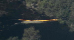
that yellow thing in the river, Sabal Trail?
Is that a sinkhole you’ve marked at the Lowndes County HDD site?
And
does blue pipe mean thinner for rural areas like
your executive from Houston told us in WWALS v Sabal Trail & FDEP?
What is
that yellow thing in the river, Sabal Trail?
Is that a sinkhole you’ve marked at the Lowndes County HDD site?
And
does blue pipe mean thinner for rural areas like
your executive from Houston told us in WWALS v Sabal Trail & FDEP?
FERC gave you permission to drill under, not on top of, the Withlacoochee River. Drilling at all there is risky, because of sinkholes. Thinner pipe farther along is still in sinkhole-prone karst terrain.

Closeup
yellow thing in Withlacoochee River, 30.7958970, -83.4530590
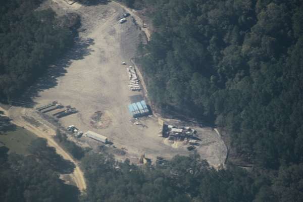
See also a report from the ground, HDD equipment truck at Withlacoochee River Lowndes County Sabal Trail site 2016-10-05. And see Sabal Trail’s maps, online courtesy of Lowndes Area Knowledge Exchange.
Closeup: is
that round thing a sinkhole at Sabal Trail Withlacoochee River HDD Lowndes County? 30.7875350, -83.4459860
See the google map for where these things are.

One blue pipe by red pipe, 30.8061440, -83.4628970
And here’s a video flyover.
Videos by John S. Quarterman for WWALS Watershed Coalition,
Flight courtesy of Southwings 22 October 2016.
John S. Quarterman (WWALS), Dominick Gheesling, Roy Zimmer (Southwings), Jim Tatum (OSFR)
Thanks to Dominick Gheesling for taking these pictures in the air; thanks to Phil Hubbard for the camera and lens, thanks to Julie Bowland for producing, thanks to Jim Tatum of Our Santa Fe River for coming along, thanks to Roy Zimmer of Southwings for the flight, and thanks to Dave Moore of Southwings for patience.
US 84 Quitman Gauge 1.67′ (85.17′ NAVD88).
-jsq
You can join this fun and work by becoming a WWALS member today!
What is that yellow thing in the Withlacoochee River, Sabal Trail, at Lowndes County HDD?
Extreme closeup yellow in Withlacoochee River, 30.7952780, -83.4524840

Closeup yellow in Withlacoochee River, 30.7958970, -83.4530590

Closeup yellow in Withlacoochee River, HDD, Brooks County, 30.7955490, -83.4528230

Yellow what in Withlacoochee River? 30.7953920, -83.4526560

What is in the river? 30.7948360, -83.4529480

What is that in the river in line with HDD? 30.7953580, -83.4532550

HDD, skeet shooting, and what is that in the river? 30.7956880, -83.4556540

HDD river access path, 30.7957210, -83.4532470

CSX RR bridge, and what is that in the river? 30.7928760, -83.4534010

CSX RR, 30.7928310, -83.4542130

US 84 and CSX RR bridges, 30.7930820, -83.4539090

Red pipe aimed at Withlacoochee River, 30.8060060, -83.4631930

One blue pipe by red pipe, 30.8061440, -83.4628970

Start of red pipe, 30.8062070, -83.4628310

House within blast radius, 30.8081810, -83.4592230

Red pipe context, 30.8040010, -83.4609670

Truck at red pipe, 30.8040470, -83.4612630

Red pipe to HDD, 30.8034930, -83.4636230

Red pipe to HDD to HDD, 30.8031880, -83.4630360

Both Sides, Withlacoochee R. HDD, 30.8019200, -83.4617810

Placing red pipe, 30.8016980, -83.4581530

S. to placing red pipe, 30.8037010, -83.4575560

SW to placing red pipe, 30.8029350, -83.4570220

Placing red pipe to start of red pipe, 30.8065760, -83.4598470

Access road to placing red pipe, 30.7949090, -83.4591340

S. to HDD and Withlacoochee River, 30.7997550, -83.4556180

Looking s. to US 84, 30.8003570, -83.4553920

Access to Brooks County HDD, 30.7935300, -83.4593830

S. to Brooks County HDD and Spook Bridge, 30.8003890, -83.4549580

Spook Bridge, Brooks County HDD 30.7898350, -83.4516640

Spook Bridge from Brooks County HDD, 30.7991170, -83.4537260
Is that round thing a sinkhole, Sabal Trail, at Lowndes County HDD?

Closeup: is that round thing a sinkhole at Sabal Trail Withlacoochee River HDD Lowndes County? 30.7875350, -83.4459860

N. to HDD Martin Lane, 30.7846860, -83.4488940

Houses within blast radius, 30.7853480, -83.4447030

HDD, Martin Lane houses within blast radius, 30.7871400, -83.4468420

Carter Road, Martin Lane, CSX RR, 30.7892250, -83.4438180

HDD, Martin Lane, Carter Way, Old Quitman Road, US 84 30.7858750, -83.4481320

Old Quitman Road, Withlacoochee River, 30.7905420, -83.4447580

Closed part of Old Quitman Road, 30.7904770, -83.4468800

HDD, Martin Ln, Tiger Creek, Carter Wy 30.7866310, -83.4440420

HDD under Tiger Creek, 30.7885990, -83.4478370

HDD & Tiger Creek, 30.7882670, -83.4474140

Spook Bridge, Lowndes County HDD, 30.7899520, -83.4501990

Sabal Trail marked across US 84, 30.7936580, -83.4511040
Google map
Follow the link or use the version embedded below.
Short Link:
Pingback: Sabal Trail preparing to drill under Withlacoochee River in Georgia 2016-10-05 | WWALS Watershed Coalition
Pingback: Sabal Trail maps digitized | WWALS Watershed Coalition
Pingback: Non-answers in Sabal Trail Biweekly Status Report 2016-11-04 | WWALS Watershed Coalition
Pingback: What is Sabal Trail sending into the WIthlacoochee River between Quitman and Valdosta, GA? WWALS PR 2016-11-09 | WWALS Watershed Coalition
Pingback: Drilling mud oozing up into the Withlacoochee River from Sabal Trail HDD | WWALS Watershed Coalition