
Sent just now as PDF. You can still send in your comments today.
![[Who wants to boat, fish, bird, or hunt next to a strip mine?]](https://www.wwals.net/pictures/2019-09-12--wwals-usace-tpm/2019-09-12--WWALS-USACE-TPM-0001.jpg)
Who wants to boat, fish, bird, or hunt next to a strip mine? PDF
September 12, 2019
To: Col. Daniel Hibner, Commander, U.S. Army Corps of Engineers, Savannah District
Attention: Ms. Holly Ross, holly.a.ross@usace.army.mil
1104 North Westover Boulevard, Suite 9, Albany, Georgia 31707
Cc: Stephen Wiedl, Wetlands Unit, stephen.wiedl@dnr.ga.gov
Georgia Department of Natural Resources, Environmental Protection Division,
Water Protection Branch, 7 Martin Luther King, Jr. Drive, Atlanta, GA 30334
Re: Applicant: Twin Pines Minerals, LLC, Application Number: SAS-2018-00554
Dear Colonel Hibner,
Suwannee Riverkeeper for WWALS Watershed Coalition (WWALS) asks USACE:
- to reject the subject Application from Twin Pines Minerals (TPM), given the inappropriate location which would over the years move ever closer to the Okefenokee Swamp, which is the headwaters of the Suwannee and St. Mary’s Rivers, combined with the numerous omissions from the Application regarding the wide hydrogeologic, water quality, ecologic, and economic ramifications of the proposed mining, and the numerous other mines relevant to the proposal.
If USACE continues to process the Application, WWALS requests USACE:
- to require a complete hydrogeological assessment and report, a full Environmental Impact Statement (EIS), and an economic analysis, with all three covering all the relevant features, mines, and applications in south Georgia and north Florida, including at least those outlined in this letter.
- to accept comments until at least ninety days after all these documents are submitted to USACE and distributed to the public, preferably on USACE’s website, without requiring site visits to Albany to get them.
- to hold public hearings in Georgia and Florida for further independent input and review after sufficient time (months or years) for independent third-party review.
The proposed Charlton County, Georgia, TPM mine site is hydraulically upgradient from the Okefenokee Swamp and within close proximity to the boundary of the Okefenokee National Wildlife Refuge (ONWR), with its 600,000 visits per year for boating, birding, and fishing, with more than $60 million annual economic effects including hundreds of jobs supported directly or indirectly, plus hunt clubs surrounding the Swamp. The Swamp provides ecosystem services of great economic values, including storm protection, water quality provisioning, support for nursery and habitat for commercial fishing species; and carbon storage, plus those hunt clubs depend on the Swamp. Any pollution of the Swamp or change in surface or groundwater levels could adversely affect not only ONWR and nearby areas, but also the Okefenokee Swamp Park (OSP) near Waycross, in Ware County, GA, and Stephen C. Foster State Park (SCFSP) in Charlton County, via Fargo in Clinch County. Visitors come from Jacksonville, Florida, Brunswick and Valdosta, Georgia, and from much farther away to visit the Okefenokee Swamp. The Swamp is a treasure to the entire nation and the world.
The stigma of a strip mine next to the swamp could cause people to turn away, taking their dollars with them. Who wants to boat, fish, bird, or hunt next to a strip mine?

Photo:
John S. Quarterman,
Okefenokee NWR at Stephen C. Foster State Park
The Swamp is the headwaters for the Suwannee River, which flows into Florida, and the underlying Floridan Aquifer does not stop at the state line, which is formed eastwards by the St. Marys River, which flows out of the Swamp. A complete application and the USACE consideration process must include many elements in north Florida. The miners either plan to process the ore in “Starke,” which is in Bradford County, Florida, and also in the Suwannee River Basin, as they told multiple organizations, or they do not, as they said later at public meetings they organized. Nonetheless, TPM and Chemours are already under a Consent Order by the Florida Department of Environmental Protection (FDEP) for violations in four mines in north Florida, from that Bradford County mine north to Baker County. Chemours recently bought Southern Ionics, which owns another mine farther north in Charlton County, Georgia. Bradford County and Union County, Florida, also have received permit applications for a phosphate mine, called HPS II. There is an existing phosphate mine, currently owned by Nutrien, in Hamilton County, Florida, downstream on the Suwannee River from the Okefenokee.
All these mines affect the Suwannee River Basin and the Floridan Aquifer, both of which span south Georgia and north Florida; see Figure 1. Due to the wide geographical scope of the relevant hydrogeologic, water quality, ecologic, and economic issues and projects, an Areawide EIS (AEIS) would be most appropriate. At minimum, USACE should require an Environmental Impact Statement (EIS) meeting all the USACE standards, which would include all the swamp features, mines, rivers, and aquifer aspects WWALS lays out in this comment letter.
![[Many mines in south Georgia and north Florida]](https://www.wwals.net/pictures/2019-09-12--wwals-usace-tpm/many-mines.jpg)
Figure 1: On a south-north line up Trail Ridge, the four Florida Consent Order Chemours and TPM mines in north Florida, then in Charlton County, Georgia, Applicant’s site and the Chemours Mission Mine South, plus to the west the existing Nutrien (PCS) phosphate mine in Hamilton County, Florida, and the proposed HPS II phosphate mine in Union and Bradford Counties, Florida, along with the upper Suwannee River Basin flowing southwards towards the Gulf, and the St. Mary’s river visible flowing to the Atlantic.[1]
Hydrogeological Report
At the July 18, 2019, Charlton County Commission meeting, we learned that the miners are still working on a hydrogeological report for the proposed mining site. It is imperative for USACE to stop the comment deadline clock until that report is submitted and distributed to the public. Potential impacts of the mine cannot be evaluated without said report.
Appendix F of the Application includes a list of hydrogeologic tasks completed or in progress. While it appears the applicant is applying considerable resources to this matter, the work in progress should not be considered a substitute for a comprehensive hydrogeologic assessment in which data are compiled and evaluated by licensed professionals. Once this assessment is complete, independent peer review should follow.
How will USACE require such a hydrogeological report to be produced and made public?
How can USACE determine the correctness and completeness of any hydrogeological report supplied by the Applicant?
We expect that USACE will have its own subject matter experts review and critique said report and that comments will be made available to the public.
Given that the first step in this process, i.e. submission of a completed hydrogeological report by the applicant, has not been completed, it is puzzling that USACE has set a deadline for comments. Is this because USACE currently expects only an Environmental Assessment (EA)?
Again, informed comment cannot be made without the aforementioned assessment. It is imperative that USACE keep the comment period open until a peer-reviewed hydrogeologic assessment is provided with sufficient time for review and comment by the public. How will USACE ensure time and opportunities for public review and comment?
As noted in the August 22, 2019 comment letter from Okefenokee Swamp Park (OSP) near Waycross, in Ware County, GA,[2] any lowering of the water level of the Swamp due to mining activities would affect all the access points to the Swamp, including OSP on its north edge, farthest from the proposed mine site. As OSP spelled out, possible hydrological effects of the TPM mine on the Swamp cannot be limited to current conditions, but must also examine drought, flood, and decreased or elevated temperatures, including a sensitivity analysis. How will USACE require the Applicant to provide sensitivity analysis of all those and other relevant conditions and scenarios, not just typical ones, but also potential extreme conditions?
ONWR on the east and OSP in the north are not the only park entrances that could be affected by water levels. On the west, Stephen C. Foster State Park (SCFSP) is in Charlton County, via Fargo in Clinch County, with road signs in Valdosta. How will the sensitivity analysis account for effects of water levels in the Swamp on all three principal Swamp entrances, plus Kingfisher Landing between ONWR and OSP?
Not just the surface water level, also the underground water table could be affected by mining, as the U.S. Fish and Wildlife Service has emphasized:[3]
THREATS AND PROBLEMS
Mining/Oil/Gas
Strip mining for titanium has been proposed on 22,000 acres directly adjacent to the southeastern boundary of the swamp. The Service has many concerns regarding strip mining and its proximity to this globally unique resource – The Okefenokee Swamp. Potential impacts include:
- Alternations to water table elevation in the swamp as a result of changes to surface and ground water quantities and flows of the Trail Ridge;
- Destruction of endangered and rare species and their habitats;
- Destruction of wetlands;
- Reduction of air and water quality through the release of contaminants; and
- Degradation of the wilderness experience for refuge visitors.
This same threat was recently eliminated from 16,000 acres adjacent to the northeastern boundary of the refuge when E.I. DuPont De Nemours and Company, Inc., donated it to The Conservation Fund.
TPM has also applied to GA-EPD for 4.32 million gallons per day of water withdrawal, split among three proposed wells.[4] How will USACE evaluate the Applicant’s assertions about effects of this water withdrawal on the Floridan Aquifer, the Okefenokee Swamp, and nearby drinking, agricultural, and industrial water wells? How will USACE ensure independent third-party peer review will be performed and USACE will take its results into account? How will USACE ensure that if these water withdrawals are permitted, that there is adequate monitoring and reporting of actual withdrawals and their effects?
What monitoring will there be to evaluate mixing of surface and ground water as a result of the mining operations?
With regard to hydrologic assessment, WWALS would also like to emphasize that any and all impacts to the Floridan aquifer in the region be evaluated. A study published by a University of Georgia team has indicated that the swamp is hydraulically linked to the underlying aquifer (Kitchens and Rasmussen, 1995).[5]
"The Okefenokee Swamp is situated near several large pumping nodes along the southeastern coast of Georgia. Groundwater extraction from the Brunswick and St. Marys regions have caused a substantial lowering of the piezometric surface in the Floridan aquifer which serves as the source of water for municipal and industrial water demands."
That paper actually understates the wide geographical effects of pumping on the Floridan Aquifer.
The North Florida Regional Water Supply Plan (NFRWSP),[6] prepared by Florida’s Suwannee River Water Management District (SRWMD) and St. John’s River Water Management District (SRWMD), using the North Florida-Southeast Georgia (NFSEG) regional groundwater flow model,[7] examined effects of pumping by Savannah, Georgia, and Jacksonville, Florida, on south Georgia and north Florida. While flawed,[8] the NFRWSP does indicate the widespread geographical implications of water withdrawals. See Figure 2.
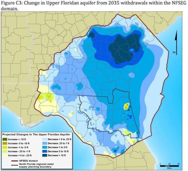
Figure 2. Widespread effects of water withdrawals on water levels in the Floridan Aquifer illustrated in NFRWSP.[9]
The Floridan aquifer is the primary water supply for southeast Georgia and northeast Florida. It is widely recognized that the aquifer is under stress due to high rates of water withdrawal and that this threatens both urban and rural water supplies in the region. All reasonable efforts should be made to protect this critical water resource.
How will USACE determine how the mine’s impact on local hydrology would likely or could potentially adversely affect the aquifer?
How will USACE require the applicant to provide a detailed assessment of water quality within areas that may be impacted by mining activities?
One of the tasks described in Appendix F of the application was collection and analysis of surface and groundwater water samples to establish background water quality. However data were not provided.
How will USACE require this water quality data to be collected and provided by Applicant, and made available to the public, at the Applicant’s expense?
In addition, considerably more effort is needed to characterize water quality within areas of potential impact. It appears that the work completed to date was limited to collection of single set of samples and that they were tested for a small number of water quality parameters. Water quality in surface and shallow groundwater varies seasonally and with storm events thus more sampling is needed that takes this into account. That failure to collect or report adequate water quality samples is among the reasons Applicant is already under a Florida Consent Order emphasizes the importance of sampling and reporting in and near the Application Georgia mine site.
How will USACE require Applicant to sample, compare, and characterize water quality and effects in wider areas and over seasons?
One critical next step in water quality assessments is testing for mercury, both total and its most toxic from methylmercury. Atmospheric deposition of mercury within the ONWR and surrounding areas is well documented (MDN). There has been a monitoring station with the refuge since 1997. Data from this station has shown that the rates of mercury deposition in the ONWR are some of the highest reported across the continental USA (see Figures 3 and 4).
![[Mercury Deposition USA 2009]](https://www.wwals.net/pictures/2019-09-12--wwals-usace-tpm/Mercury_depostion_USA_2009.jpg)
Figure 3: Total Mercury Wet Deposition, 2009 (NADP) CC by 4.0[10]
The toxic impacts of mercury are well known. This includes accumulation of a highly toxic form of the element in fish tissue. This is why there is a health advisory on fish consumption in the region.[11] and Total Maximum Daily Load (TMDL) assessments have been made on both the St. Mary’s[12] and Suwannee Rivers[13]. A detailed review of the published scientific literature (Grigal, 2003)[14] has indicated that in wetland environments such as those in the proposed mining area, mercury deposited from the atmosphere tends to be geochemically immobilized in soils and sediments. The same review has also reported that exposure of mercury contaminated soil and sediment to air can release the mercury making it more mobile and increasing potential for toxic impacts. In the application the miners have reported that they remove the topsoil from the mining site and return it after mining is complete. In both cases soils will be exposed to the atmosphere and this will likely change the mercury residing in the soil to forms which are more mobile, leachable, and bioavailable. Adverse impacts to water quality and as a result to the ecosystem are likely. This includes increased mercury uptake in fish and further restrictions on their consumption. As noted in the TMDL’s for the St. Mary’s and Suwannee Rivers that are near the mining site, a 56 to 58 % reduction in mercury loading is needed to meet acceptable water quality standards (TMDLs). Release of mercury from contaminated soils during mining operations can only make the situation worse.
![[Annual mercury deposition OKNWR]](https://www.wwals.net/pictures/2019-09-12--wwals-usace-tpm/Annual-mercury-deposition_OKNWR_html_fa8d4c2b3cd0b279.jpg)
Figure 4: Annual mercury wet deposition, ONWR, from NADP.[15]
How will USACE require Applicant to account for potential effects of its mining and transportation activities releasing mercury, potentially making TMDLs worse?
In summary, USACE should require the hydrogeological report to include but not be limited to the examples described here, such as better data collection and reporting, and accounting for unearthing of previously-deposited mercury. Once again, USACE should accept comments until at least ninety days after a full hydrogeological report, along with the other documents indicated in this letter, is not just submitted to USACE but also distributed to the public.
Environmental Impact Statement (EIS)
The relevant considerations for an EIS for this TPM application go far beyond Charlton County in Georgia, and beyond Georgia into north Florida..
The present Applicant, TPM, is cited in a February 2019 Florida Department of Environmental Protection (DEP) Consent Order against Chemours in Florida,[16] including for lack of monitoring data, and for being out of compliance on numerous counts in the data that was collected, including for radium and iron. Other specific mentions relevant to the current Application include:
On page 4 of the Consent Order:
6) A permit modification for Trailridge Facility to include Twin Pines in the Industrial Wastewater permit was not obtained prior to beginning operation.
What wastewater permit does TPM plan to use for its Charlton County mine? Where is its application for that permit? How will USACE require the Applicant to supply this information?
The location of the Chemours Trailridge mine is given on page 2 of the Consent Order as:
The Trailridge Facility is located at 5222 Treat Road Starke, Florida 32091, in Bradford County, Florida, Latitude: 29 0 54' 46.15" N, Longitude: 82 0 1 ' 52.35" W ("Trailridge Property").
This is the only one of the four Chemours mines cited in the Consent Order that has a Starke address, so one can infer that it is the location that TPM meant when it told multiple organizations that it would send ore to be processed in “Starke.” How will require the Applicant to spell out in detail what ore, how much, to where, bu what means of transport, and what kind of processing?
On page 5 of the Consent Order:
3) Twin Pines silt fence was overwhelmed with sand; process water and tailings fill deposited in a wetland without permit authorization;
How will USACE require the Applicant to provide specific assurances of how TPM will prevent this and other violations that happened in Bradford County, Florida, with methods of independent third-party verification, and penalties for violations, up to and including shutting down operations?
On page 9:
e) Twin Pines Mitigation Plan: Within ninety (90) days of the effective date of this Order, Respondent shall provide mitigation to offset the relative functional wetland losses caused by the fill from the Twin Pines area that was deposited into the adjacent wetland without permit authorization.
How will USACE require Applicant to account for everything required by FDEP in that Florida Twin Pines Mitigation Plan, with specific assurances of how TPM will prevent these violations and mitigate them if they happen, with methods of independent third-party verification, and penalties for violations, up to and including shutting down operations?
How will USACE require Applicant to account for every violation or requirement cited by FDEP in the Consent Order or the preceding FDEP Warning Letter,[17] with specific assurances of how TPM will prevent these violations and mitigate them if they happen, with methods of independent third-party verification, and penalties for violations, up to and including shutting down operations?
How will USACE require the Applicant to account for effects on the Floridan Aquifer, the Okefenokee Swamp, and the Satilla River of the Chemours mine recently acquired from Southern Ionics, Mission Mine South near Winokur Road in Charlton County, GA,[18] together with comparisons to the methods and situation of the subject Application? See for example the southern expansion of that Chemours Mission Mine South, USACE Applicant Southern Ionic Minerals LLC, Application No. SAS-2012-01042-SP-JML.[19]
![[WC6232, Tom Harris Road @ Fire House Road, 23:12:14, 30.99589, -81.97775]](https://www.wwals.net/pictures/2019-08-24--jim-tatum-southwings-okefenokee-tpm/WC6232.jpg)
Photo: Jim Tatum, Chemours (Southern Ionics) Mission Mine South, Charlton County, GA, 2019-08-24.
How will USACE require Applicant to include effects on the Floridan Aquifer, the New and Santa Fe Rivers, and the Suwannee River Basin, of the four Chemours mines under the Florida Consent Order, together with comparisons to the methods and situation of the subject Application? The Chemours North Maxville Mine in Baker County, Florida, is currently expanding; see Applicant The Chemours Company FC LLC, Application No. SAJ-2006-00155 (MOD-JPF).[20]
![[WC6170, 22:40:34]](https://www.wwals.net/pictures/2019-08-24--jim-tatum-southwings-okefenokee-tpm/WC6170.jpg)
Photo:
Jim Tatum, Chemours North Maxville Mine in Baker County, FL, 2019-08-24
How will USACE require Applicant to include effects on the Floridan Aquifer, the New and Santa Fe Rivers, and the Suwannee River Basin, of the proposed HPS II phosphate mine in Union and Baker Counties, Florida,[21] together with comparisons to the methods and situation of the subject Application? HPS II apparently has not yet filed a permit application with USACE, but the HPS II website says they plan to.
How will USACE require Applicant to include effects on the Floridan Aquifer, massive reductions in water level of White Sulfur Spring, and effects on the Suwannee River, of the Nutrien (formerly PCS) phosphate mine in Hamilton County, Florida, together with comparisons to the methods and situation of the subject Application? See for example Nutrien’s most recent USACE permit application, SAJ-1984-04652.[22]

Photo: Jim Tatum for WWALS,
Nutrien (PCS) phosphate mine, Jasper, FL, 2016-10-22.
How will USACE evaluate together the effects of all these existing or proposed mines, as they keep coming back to USACE for further permit alterations or new permits?
According to the U.S. Council on Environmental Quality (CEQ),[23]
The preparation of an area-wide or overview EIS may be particularly useful when similar actions, viewed with other reasonably foreseeable or proposed agency actions, share common timing or geography. For example, when a variety of energy projects may be located in a single watershed, or when a series of new energy technologies may be developed through federal funding, the overview or area-wide EIS would serve as a valuable and necessary analysis of the affected environment and the potential cumulative impacts of the reasonably foreseeable actions under that program or within that geographical area.
The Chemours and TPM mining projects and applications demonstrate a variety of titanium mining projects in the same watersheds (St. Marys and Suwannee) and above the Floridan Aquifer. The HPS II and Nutrien phosphate mines demonstrate a variety of phosphate mining projects in the same watershed (Suwannee) and above the Floridan Aquifer.
How, for those watersheds and the Floridan Aquifer, will USACE perform “a valuable and necessary analysis of the affected environment and the potential cumulative impacts of the reasonably foreseeable actions under that program or within that geographical area”?
Titanium was recently identified by the U.S. Geological Survey as a critical mineral resource of the United States, with drawbacks to mining it:[24]
Environmental considerations for titanium mining are related to waste rock disposal and the impact of trace constituents on water quality. Because titanium is generally inert in the environment, human health risks from titanium and titanium mining are minimal; however, the processes required to extract titanium from titanium feedstock can produce industrial waste….
Although titanium may not be an environmental concern, other metals found in trace sulfides may be deleterious to the environment. Some metals, such as cobalt, nickel, and zinc, will remain in solution even at neutral pH. Drainage water with near-neutral pH and some quantity of dissolved metals is termed “contaminated neutral drainage.”…
These studies suggest that ecosystem health concerns from high nickel concentrations in mine drainage waters may increase as mine wastes weather….
Disposal of tailings underwater can lead to increased water turbidity, however, and, depending on the sedimentation rate, to the smothering of organisms living in bottom sediment.
![[Closeup]](https://www.wwals.net/pictures/2019-07-30--chemours-dredge/IMG_2032.jpg)
Photo: Carol Burton,
Dredge operation at Chemours North Maxville Mine in Baker County, FL, 2019-07-30.
How will USACE determine which organisms might be smothered by such slimes, for example, would they include catfish?
The same USGS reference raises the question of particle size of slimes:[25]
Mining and milling methods for heavy-mineral sand deposits involve physical separation of a bulk concentrate and quartz-rich tailings by mechanical means, typically magnetic or electrostatic methods or density separation. During further concentration, the mineral-bearing sand fraction is separated from finer textured slimes (clays, silts, very fine sand), which is mixed with a flocculent to aid settling, and then pumped back as a slurry into a reclamation pit (Daniels and others, 2003).
The average grain size of heavy minerals and the percentage of slimes in a deposit are variable, which results in different amounts and types of waste material. For example, two mineral-sand blocks in India (Kuttam and Sattankulam) contain up to 10 percent heavy minerals and 15 percent slimes (Murty and others, 2007). The sands in these blocks are very homogeneous—85 percent of the sands range from <2 millimeters to 63 µm in size. Heavy-mineral sands on the northeastern coast of Sri Lanka (Pulmoddai sands) are very high grade; 71 percent of the beach sands are smaller than 355 µm, and more than 99 percent of the titanium content is in this size fraction (Premaratne and Rowson, 2003). The two blocks in India cover approximately 120 square kilometers (km2 ) and contain an estimated 400 million metric tons of raw sand and 30 million metric tons of ilmenite (Murty and others, 2007). Pulmoddai sands cover an area of only 3.2 km2 with an even thickness of 6 m (Premaratne and Rowson, 2003); thus, the amount and type of waste generated by the two deposits in India would be very different than the waste generated at Pulmoddai….
Recent findings do suggest that TiO2 nanoparticles, commonly defined as particles smaller than 100 nanometers in at least two dimensions, may be toxic to some aquatic and terrestrial organisms (Federici and others, 2007; Wang and others, 2008; Sharma, 2009).
TPM is already under a Florida Consent Order partly for its silt fences failing to contain its slime ponds during Hurricane Irma.
Three of the four Chemours mines in north Florida where TPM is already active were the only sources of industrial wastewater spills in the Suwannee River Basin in Florida during Hurricane Irma.[26]
At North Maxville Maine, “Stormwater and process water was released from the emergency spillways at at one mining cell (turbid water – no hazardous materials or chemicals). Discharge from the emergency spillways ceased over the course 2 dyas days.” Does “no hazardous materials or chemicals” mean no slimes were spilled, even though that is what those ponds are meant to contain?
At Maxville Mine, “Stormwater and process water was released from the emergency spillways at 4 of the ponds on the site (turbid water – no hazardous materials or chemicals). Discharges from the emergency spillways ceased over the course of a few days. , , Additionally, turbid water was released from NPDES point (D001). Due to high winds, sediment was not able to be settled from the water column.”
At Trail Ridge Mine, “Stormwater was released from the emergency spillway at the West Levee.”
Hurricane Dorian stayed offshore just now, or we might have witnessed more such spills. How will the sensitivity analysis consider hurricane conditions among others, including what might be spilled, including slimes, and what effects such spills might have?
How will USACE determine how much such a failure at its Charlton County mine site could affect terrestrial organisms on the mine site or in nearby hunt clubs, or aquatic organisms in the St. Mary’s River, the Okefenokee Swamp, or the Suwannee River, and how likely such a failure and such effects may be?
In addition to the particle size, the concentration of slimes can be a problem for several reasons, including structural characteristics of mine tailings:[27]
Results of the slump testing and physical condition of test specimen indicated that the maximum amount of slimes that could practically be included in the tailings sand without excessively affecting the stability of tailings backfill slope is about 10%.
The intent of TPM to mix the subsoils could exacerbates this problem:
Full mixing has two effects. Slimes are uniformly distributed within sand matrix such that the lower strength slimes will affect porosity and sand grain contact, resulting in a reduction of the sand strength. Secondly, the shearing that is imparted to the slimes may break down the flocculated structure formed by the thickening process.
Stability and other properties of slimes vary with local site climate:
Geotechnical studies and tailings co-disposal methodology has revealed that a maximum 10% slimes can be blended with the sand for use as mine backfill material, but may be significantly lower depending on actual moisture content of the sand, slimes density actually achieved through thickening, material handling and the site climatic conditions.
Amounts of intermixed clays also pose problems:
The presence of about 15% slimes in ROM sand coupled with scarcity of water at the project site complicates the slimes handling/disposal system, requiring the development of an innovative, efficient and effective system for disposal of slimes. Mineral characteristics of slimes revealed the presence of kaolinite clay, which poses its own challenges in thickening/dewatering of slimes.
How will USACE determine, for the Applicant’s TPM mine, compared to each of the four Florida Consent Order Chemours mines, the Chemours Mission Mine South in Charlton County, Georgia, the Nutrien phosphate mine in Hamilton County, Florida, and the HPS II phosphate mine proposed in Bradford County, Florida, as well as the Chemours mines in Wayne County, Georgia (see below):
- What is the slime particle size and percentage for titanium dioxide and other mining byproducts that can be expected to be produced?
- What is the percentage of clay, overall, and compared to other slime components?
- What is TPM’s plan to deal with slimes during both droughts and wet swampy conditions, including hurricanes, compared with both plans and actual practice at the other mines?
- What are TPM’s Toxicity Characteristic Leaching Potential (TCLP) assessments, compared to those for the other mines?[28]
The Floridan Aquifer extends farther north than Charlton County, as do heavy mineral deposits, at least as far as the Amelia A and B mineral sands near Jesup in Wayne County, GA; see Figure 5. When DuPont in August 2014 withdrew its application with GA-EPD to mine Amelia A and B because of public outcry, it was reported:[29]
DuPont planned to separate the mineral sands from the rest and then truck that to its facility in Starke for final processing….
As in other uses noted above, Starke seems to refer to the Chemours Trailridge Facility on Trail Ridge southeast of Starke, Bradford County, Florida.
[DuPont company spokeswoman Tara] Stewart said the company is capable of mining in a way that will address the concerns.
“We’ve been mining 80 years, 60 in Florida,” she said. “We know how to do this well.”
Yet Chemours, successor of DuPont in north Florida, is under a Florida Consent Order for those same north Florida mines, along with TPM, the present Applicant.
How will USACE determine what the concerns were about the DuPont Amelia A and B mining proposal, what DuPont and later Chemours has done about them, how successful those actions were, and how they compare to what Applicant proposes to do?
In 2015, DuPont spun off Chemours, which in 2016 again proposed to mine Amelia A and Amelia B, once again with ties to Starke:[30]
…According to a public advisory that was discovered by local resident Betty Benner, the application is for the same two mines, Amelia A and B, that were proposed in the earlier application. The mining would be on 2,653 acres, the advisory stated, and would be for “heavy mineral sands.”
Contacted about the application, C.J. Hilton, head of titanium mining for Chemours in Starke, Fla., acknowledged that the application had been filed.
A Chemours website about this mining operation describes mining methods much like what little description we have seen thus far from the present Applicant, and once again ties the Amelia A and B mining operation to Starke:[31]
Using a minimally invasive mining process, the minerals—which constitute approximately three percent of the soil—are extracted using an on-site gravity spiral separation process that does not require chemicals. Once the desired mineral ores, titanium, zircon, and staurolite, are separated, the restoration of topsoil and planting of tree seedlings and native grasses takes place.
Separated minerals will be shipped to our Starke, Florida facility for further processing. The estimated initial investment of more than $20 million in the first year of operation and $18 million each following year is expected to create over 60 full-time positions.
Yet when Southern Ionics Minerals (SIM) in 2018 agreed with Chemours to mine those Wayne County deposits, SIM wrote:
Mineral sand concentrate will be produced at the mine, then trucked to SIM’s Mineral Separation Plant in Offerman for further processing. Shipping of Chemours’ final products will be managed by Chemours.
Which is it? Starke or Offerman?
How will USACE require the present Applicant to specify where and how its ores will be processed, and if they are to be shipped for remote processing, how they will be shipped, how much, and with what effects on local transportation infrastructure?
The CSX railroad runs from Jesup through Folkston to Starke, but it bypasses St. George.
How will USACE determine what form of transportation Applicant will use to ship ore to process, how much, and what effects will that transportation have on local infrastructure not built for such heavy use, as well as environment, quality of life, and property values?
A Presidential Executive Order of the day after the USGS critical minerals report wrote about reliable supplies of critical minerals:[32]
The United States will further this policy for the benefit of the American people and in a safe and environmentally responsible manner, by:…
(iv) a plan to improve the topographic, geologic, and geophysical mapping of the United States and make the resulting data and metadata electronically accessible, to the extent permitted by law and subject to appropriate limitations for purposes of privacy and security, to support private sector mineral exploration of critical minerals;
How can USACE determine whether it is only possible to mine with such slimes in a safe and environmentally responsible manner, other than by examining all these mining projects together, thus also contributing to the mapping indicated by the Executive Order?
As CEQ’s longer Final Guidance for Effective Use of Programmatic NEPA Reviews notes:[33]
"Stakeholders for a programmatic review may span multiple states and large areas."
The various projects and water and land features mentioned above in this letter may not be all of those that are relevant to this TPM Application.
How can USACE determine which projects and features are relevant without holding holding Scoping Meetings?
The term, Areawide, is not the most important part of the EIS. Any EIS should include all the features indicated in this letter, across this broad geography of the Okefenokee, St. Mary’s, and upper Suwannee River Basins, together with the Floridan Aquifer.
Once again, USACE should accept comments until at least ninety days after a full EIS, along with the other documents indicated in this letter, is not just submitted to USACE but also distributed to the public.
Economic Analysis
The Application did not include a Master Mining Plan, which should have answered many of the questions raised in this section of this letter. USACE should require an Economic Analysis with such a Master Mining Plan.
Since mid-July, news reports say the miners have been claiming numbers of jobs in excess of the numbers in the application:[34]
Asked for comment on the application, a lobbyist for Twin Pines Minerals, Steve Allen of Joe Tanner & Associates, responded with a written fact sheet that reiterated much of the material in the application. It added an anticipated start date for mining activities, however, of January 2020. It is anticipated that the proposed facility will have an operational life of eight years, the fact sheet stated. It also changed the estimate of workers from the “full-time employment of approximately 150-200 workers from the local area” listed in the application to “this activity will result in the full-time employment of approximately 300 workers.”
And again, in an Associated Press story that has been picked up across the country:[35]
Twin Pines Minerals said it plans public meetings in southeast Georgia in August to further discuss its plan, which the company said includes employing roughly 300 workers.
Residents of Baker and Bradford Counties, Florida, home to some Chemours mines that are subjects of the Consent Order, say that they have not been able to find anyone local who is actually employed by Chemours, despite earlier promises of large numbers of jobs, similar to those now being made by TPM.
How many jobs could the mine proposed by TPM realistically be expected to provide? How many of those might be filled by local people? Zero, as may be the case with the Chemours mines in Florida? 100-150 as in the Application? 300 as TPM has been telling the press since the Application?
How many people does TPM employ in Florida at the Chemours mine sites that are the subject of the Consent Order? How many of those people are local? How many people does Chemours employ at those sites? How many of those people are local?
When asked by a Baker County Commissioner at a Public Hearing for continuation of an existing mine, Chemours claimed 63 employees, but could not even give an estimate for how many of those people were Baker County citizens.[36]
At the same meeting, the taxes paid by the mine to the county was stated as $343,000 a year. That is not close to millions of dollars. How will USACE require an Economic Analysis to determine at least the taxes paid by the various Chemours mine sites, with which to calibrate any claims by TPM of taxes it might pay?
Chemours recently bought Southern Ionic Minerals, LLC (SIM).[37] SIM filed with USACE in 2015 to expand Mission Mine South (MMS) on Winokur Road north of Folkston, in Charlton County, GA.[38] How many people does SIM (now Chemours) employ at that site? How many of those people are local?
Chemours has made many promises about jobs to be produced by its mining operations in Wayne County, Georgia. How many people does Chemours actually employ in Wayne County? How many of those people are local?
The questions above would seem the minimal amount of comparative information about employment relevant to TPM’s various claims of numbers of jobs.
The TPM Application mine would be far closer to the Okefenokee Swamp than any of the five Chemours mines (see Figure 1), and even closer than the Chemours Wayne County mines (see Figure 5).
How will USACE balance any more realistic estimate of likely jobs from the TPM mine against risks a mine that close to the ONWR would pose to the 600,000 annual ONWR visits, the hundreds of jobs ONWR supports directly and indirectly, and the millions of dollars ONWR contributes to the Charlton County and the state of Georgia, as well as potential effects of water levels on OSP, SCFSP, forestry, and hunt clubs, as well as on the rivers, and on drinking water?
Alternative 1 of the mining proposal indicated that 639 acres of wetlands will be ‘disturbed’. The Swamp provides ecosystem services of great economic values, including storm protection, water quality provisioning, support for nursery and habitat for commercial fishing species; and carbon storage (Patton et al., 2012).[39] The aggregate value of services (carbon storage, flood control, water quality protection and fishery habitat), provided by Okefenokee wetlands has been estimated to $330 per acre year. This indicates that potential losses could be $211,000 per year or more.
Various parties, including the Charlton County Commission, claim Charlton County would derive significant tax revenues from TPM’s mine.[40] The Economic Analysis should compare such claims for the five Chemours mines, with documentation for how much tax revenue has actually been booked on the tax digest and received by the counties containing those mines. Such hard data should be used to calibrate TPM’s tax revenue claims.
How will USACE obtain such hard data and calibrated tax revenue estimates, and how will USACE compare them to loss of ecosystem services, as well as potential loss of the more obvious revenue from visitors for boating, birding, fishing, and hunting, as well as potential effects on forestry, hunt camps, and the rivers?
The Economic Analysis USACE should require should include at least the points described above. Once again, USACE should accept comments until at least ninety days after a full Economic Analysis, along with the other documents indicated in this letter, is not just submitted to USACE but also distributed to the public.
Summary
The Okefenokee Swamp is a delicate and irreplaceable national and international treasure: the largest blackwater swamp in north America, with iconic alligators, black bears, and great blue herons. The Okefenokee Wilderness Area Canoe Trails are one of only two National Water Trails in Georgia. Billys Island is named for the native Americans who preceded the settlers. Alligators have recovered due to the Endangered Species Act, as has the federally endangered Sandhill Crane. Gopher tortoises inhabit the lands around the swamp, including the proposed mine site. The St. Mary’s and Suwannee Rivers are two of the few free-flowing undammed rivers left in the U.S. The Swamp and the Rivers and the surrounding hunt camps are beloved by locals and people from afar for boating, birding, fishing, and hunting. They form a local and regional economic engine.
Any spills or hydrogeological damage in Georgia by the Applicant miners, such as those in the Florida Consent Order against them, could affect the rivers and the Swamp. Such pollution or modification of surface or groundwater levels, or the mere existence of a mine so close to the Swamp, could produce stigma that could cause people to cancel trips of the three Swamp entrances (ONWR, SCFSP, and OSP) and their hundreds of thousands of visitors and millions of dollars of economic activity. This mine site is much closer to the Okefenokee Swamp than any other, about 2.5 miles, with northwards expansion getting ever closer.
This irreplaceable habitat and economic engine should not be subjected to such risk. USACE should apply the highest standards of review to any mining application near the Okefenokee, especially this one, from slimes to jobs.
Two decades ago, DuPont attempted to mine close to the Okefenokee Swamp, somewhat farther north on Trail Ridge, in the “Folkston West deposit:”[41]
Further inland, the Folkston West deposit was lost to exploitation due to environmental concerns, and the Toledo and Saunders deposits may be lost for the same reasons. These deposits are located on Trail Ridge near the eastern edge of the Okefenokee Swamp National Wildlife Refuge and extend from near Race Pond, Georgia, on the north to state road 94 on the south….
The euphemism “lost to exploitation due to environmental concerns” refers to the massive public outcry against mining that close to the Okefenokee Swamp, on the Folkston West Tract, that caused DuPont to withdraw its application.
![[Heavy Mineral Mining In The Atlantic Coastal Plain-0006]](https://www.wwals.net/pictures/2019-09-12--wwals-usace-tpm/Heavy-Mineral_Mining_in_the_Atlantic_Coastal_Plain-0006.jpg)
Figure 5:
Heavy Mineral Mining In The Atlantic Coastal Plain-0006
Trail Ridge heavy mineral deposits, including Folkston West and Saunders Tracts.[42]
The Applicant’s mine on the Saunders Tract would be even closer, and even more inappropriate, increasingly so as it would expand over time towards the Toledo Tract and closer to the Okefenokee Swamp and its massive environmental value, ecological services, and economic worth, at the headwaters of the Suwannee and St. Mary’s Rivers.
How far do the implications of Applicant’s mine go beyond their proposed site or even the Okefenokee Swamp Basin? What are the effects of all of the wetlands that have been mined, combined with what Applicant is proposing, and the thousands of acres likely to be mined in the future through further such mining?
What are the biochemical and biological changes from the preceding wetlands to the created wetlands? For example, how well will saw palmetto grow on the mining-disturbed soils? How will USACE determine these changes?
How will USACE determine potential economic ill effects of Applicant’s proposed mine, on transportation infrastructure, on hunting, fishing, birding, forestry, including the general stigma of a mine in such a sensitive area near a world-famous natural treasure?
How will USACE require the Applicant, to perform studies at Applicant’s own expense to get the relevant information? How will USACE perform appropriate review, and invite appropriate independent third-party review?
How can the present Environmental Analysis (EA) approach for this Application answer these questions?
How can USACE not conclude that an Environmental Impact Statement (EIS) is needed, with its concomitant processes and requirements?
How can USACE evaluate the cumulative effects of the type of mining proposed by Applicant, and the wide areas affected, in the entire Okefenokee Swamp Basin, the St. Mary’s and Suwannee River Basins, and beyond up Trail Ridge and further mineral sand deposits all the way to Wayne County, Georgia, all above the Floridan Aquifer, source of drinking water for the entire region of south Georgia and north Florida, without performing an Areawide Environmental Impact Statement (AEIS)?
Given the inappropriate location of the Applicant’s mine site, combined with the numerous omissions from the Application, Suwannee Riverkeeper for WWALS Watershed Coalition (WWALS) requests USACE:
- to reject the Application.
If USACE chooses to continue the permit process, WWALS requests USACE:
- to require for the subject Application, including all the geographically-widespread topics indicated in this letter:
- a hydrogeological report, with water quality and sensitivity analysis,
- a full Environmental Impact Statement (EIS), and
- an economic analysis, including a Master Mining Plan
- to extend the comment deadline to at least ninety days after all those documents are submitted to USACE and distributed to the public, preferably on USACE’s website, without requiring site visits to Albany to get them.
- to hold public hearings in both Georgia and Florida, after sufficient time for independent third-party review.
WWALS reserves the right to submit further comments on this Application, up to and beyond the current nominal comment submission deadline.
For the rivers and the aquifer,
John S. Quarterman
Suwannee RIVERKEEPER®
229-242-0102
contact@suwanneeriverkeeper.org
www.suwanneeriverkeeper.org
1 WWALS Map, All Landings in the Suwannee River Basin, accessed 5 September 2019, https://www.google.com/maps/d/u/0/viewer?mid=1dnRr3ATEwReknyLZq26-316FfydbER2K&ll=30.500833899428827%2C-82.55887663476562&z=10
2 Okefenokee Swamp Park comment letter to USACE about TPM SAS-2018-005544, 22 August 2019, https://wwals.net/?p=50052
3 Comprehensive Conservation Plan, Okefenokee National Wildlife Refuge, U.S. Department of the Interior, Fish and Wildlife Service, Southeast Region, October, 2006, Section A, page 15, https://docs.google.com/viewer?a=v&pid=forums&srcid=MDA1OTg2MDExNzIxNzgyNzY5NzQBMDUwNTIzMTMyNDMzNjMyNDkzNDMBVERiRms4ZnRCUUFKATAuMQEBdjI&authuser=1
4 Application for Industrial Groundwater Withdrawal Permit, Twin Pines Minerals, LLC, Saunders Mine, Submitted to GA-EPD Water Supply Program, Groundwater Withdrawal Unit, 24 July 2019, https://www.scribd.com/document/424772086/7-24-19-Final-Application-for-Industrial-Groundwater-Withdrawal-Permit#download
5 Kitchens, S and Rasmussen, TC. Hydraulic Evidence for Vertical Flow From Okefenokee Swamp To The Underlying Floridan Aquifer In Southeast Georgia. Proceedings of the 1995 Georgia Water Resources Conference, held April 11 and 12, 1995, at The University of Georgia, Kathryn J. Hatcher, Editor, Carl Vinson Institute of Government, The University of Georgia, Athens, Georgia. https://smartech.gatech.edu/handle/1853/44003
6 North Florida Regional Water Supply Plan, North Florida Regional Water Supply Partnership, accessed 5 September 2019, https://northfloridawater.com/watersupplyplan/index.html
7 North Florida-Southeast Georgia (NFSEG) regional groundwater flow model, North Florida Regional Water Supply Partnership, accessed 5 September 2019, https://northfloridawater.com/groundwaterflowmodel.html
8 Less withdrawals, more water retention for North Florida Regional Water Supply Plan, WWALS, 6 December 2016, https://wwals.net/?p=27688, http://wwals.com/wp-content/themes/pianoblack/img//2016/12/2016-12-05-WWALS-NFRWSP-att.pdf
9 Ibid.
10 Nair, Udaysankar & Wu, Y & D. Holmes, C & ter schure, Arnout & Kallos, George & Walters, Justin. (2013). Cloud-resolving simulations of mercury scavenging and deposition in thunderstorms. Atmospheric Chemistry and Physics. 13. 10.5194/acp-13-10143-2013. https://www.researchgate.net/publication/307836100_Cloud-resolving_simulations_of_mercury_scavenging_and_deposition_in_thunderstorms, see also Toxics & Mercury, Air Pollution Impacts, Okefenokee National Wildlife Refuge, U.S. Fish and Wildlife Service, accessed5 September 2019, https://www.fws.gov/refuges/AirQuality/ARIS/OKEF/Impacts.html
11 Georgia Department of Environmental Protection, Bulletin # FDNS-E-94-2, March 2008, A Woman’s Guide to Eating Fish and Seafood from middle and south Georgia, https://epd.georgia.gov/sites/epd.georgia.gov/files/related_files/site_page/wfcg_midsouth.pdf
12 Total Maximum Daily Load for Total Mercury in the St. Marys Watershed, GA, U.S. Environmental Protection Agency Region 4. 2002. https://epd.georgia.gov/sites/epd.georgia.gov/files/related_files/site_page/EPA_St_Marys_Watershed_Hg_TMDL.pdf
13 Total Maximum Daily Load for Total Mercury in the Suwannee Watershed, GA. U.S. Environmental Protection Agency Region 4. 2002. https://arm-permit2k.dep.state.fl.us/psd/1210471/U0001195.pdf
14 Grigal, DF. Mercury Sequestration in Forests and Peatlands: A Review. J. Environ. Qual. 32:393—405 (2003). https://www.researchgate.net/publication/10792313_Mercury_Sequestration_in_Forests_and_Peatlands
15 Data from the Mercury Deposition Network (MDN), https://nadp.slh.wisc.edu/mdn/, of the National Atmospheric Deposition Program, https://nadp.slh.wisc.edu/data/sites/siteDetails.aspx?net-MDN&id=GA09
16 Florida Department of Environmental Protection, OGC File No. 18-1240, Consent Order, 7 February 2019, https://wwals.net/2019/08/11/consent-order-fdep-v-chemours-involving-twin-pines-minerals-2019-02-07/
17 FDEP, Warning Letter No. WL18-40, 23 March 2019, The Chemours Company FC, LLC, Facility ID Nos. FL0000035, FL0000051, FL0040274 and FL0435490, Clay, Bradford, Duval, and Baker Counties, https://wwals.net/pictures/2018-03-23—fdep-warning-chemours/
18 “Chemours Acquires Mining Operations of Southern Ionics Minerals: Acquisition Will Enable Substantial Increase in Ore Production,” The Chemours Company, PRNewsWire, 2 August 2019, https://www.prnewswire.com/news-releases/chemours-acquires-mining-operations-of-southern-ionics-minerals-300894295.html
19 Savannah District, U.S. Army Corps of Engineers, Applicant Southern Ionic Minerals LLC, Application No. SAS-2012-01042-SP-JML, Published Dec. 22, 2015, Expiration date: 1/21/2016, https://www.sas.usace.army.mil/Missions/Regulatory/Public-Notices/Article/637738/sas-2012-01042-sp-jml/
20 Jacksonville District, U.S. Army Corps of Engineers, Applicant The Chemours Company FC LLC, Application No. SAJ-2006-00155 (MOD-JPF), Published March 16, 2018, Expiration date: 4/4/2018, https://www.saj.usace.army.mil/Missions/Regulatory/Public-Notices/Article/1468167/saj-2006-00155-mod-jpf/
21 HPS II Phosphate Mining Project, HPS II, accessed 5 September 2019, https://www.hpsii.net/, Fight the HPS II Phosphate Mine, Our Santa Fe River (OSFR), accessed 5 September 2019, https://oursantaferiver.org/fight-hps-ii-phosphate-mine/, Proposed HPS II phosphate mine in Union and Bradford Counties, Florida, WWALS, accessed 5 September 2019, https://wwals.net/issues/phosphate-mining/#hpsii
22 Jacksonville District, U.S. Army Corps of Engineers, Applicant: PCS Phosphate — White Springs, Application No.: SAJ-1984-04652 (MOD-JPF), Published Oct. 15, 2018, Expiration date: 11/14/2018, https://www.saj.usace.army.mil/Missions/Regulatory/Public-Notices/Article/1662437/saj-1984-04652-mod-jpf/,
PCS Phosphate Mine dragline access permit application SAJ-1984-04652 2019-10-15
[23] Council on Environmental Quality (CEQ), Forty Most Asked Questions about NEPA, 1986, accessed 3 September 2019, question 24b, https://www.energy.gov/nepa/downloads/forty-most-asked-questions-concerning-ceqs-national-environmental-policy-act
[24] Titanium, Professional Paper 1802- T, By: Laurel G. Woodruff, George M. Bedinger, and Nadine M. Piatak, Edited by: Klaus J. Schulz, John H. DeYoung, Jr., Robert R. Seal, and Dwight C. Bradley, https://doi.org/10.3133/pp1802T Chapter T of Critical mineral resources of the United States—Economic and environmental geology and prospects for future supply, USGS, Professional Paper 1802, Edited by: Klaus J. Schulz, John H. DeYoung, Jr., Robert R. Seal, and Dwight C. Bradley, 19 December 2017, https://doi.org/10.3133/pp1802
[25] Ibid.
[26] Spills in the Suwannee River Basin, in Florida Public Notice of Pollution, WWALS, 29 September 2017, https://wwals.net/?p=37541#basin, data from Florida Pollution Notices, http://prodenv.dep.state.fl.us/DepPNP/reports/viewIncidentDetails?page=1
[27] MURTY, CH.V.G.K., GURUNG, R., UPADHYAY, R., and ASOKAN, S. Tata Steel’s Titania project—challenges in slimes disposal. The 6th International Heavy Minerals Conference ‘Back to Basics’, The Southern African Institute of Mining and Metallurgy, 2007. http://www.saimm.co.za/Conferences/HMC2007/111-118_Murty.pdf
[28] CFR § 261.24 Toxicity characteristic. https://www.law.cornell.edu/cfr/text/40/261.24
[29] Terry Dickson, Jacksonville.com, 27 August 2014, DuPont withdraws application for permit to mine more than 2,200 acres in Wayne County, https://www.jacksonville.com/breaking-news/2014-08-27/story/dupont-withdraws-application-permit-mine-more-2200-acres-wayne-county#ixzz3BgSalG9A
[30] Derby Waters, The Press-Sentinel, 20-21 August 2016, Chemours applying again to mine here, http://archives.etypeservices.com/Jesup1/Magazine135881/Publication/Magazine135881.pdf
[31] Chemours, chemours.com, accessed 8 September 2019, Wayne County Prospers, https://www.chemours.com/Wayne-County-Prospers/en_US/index.html
[32] A FEDERAL STRATEGY TO ENSURE SECURE AND RELIABLE SUPPLIES OF CRITICAL MINERALS, Executive Order, The White House, 20 December 2017, https://www.whitehouse.gov/presidential-actions/presidential-executive-order-federal-strategy-ensure-secure-reliable-supplies-critical-minerals/
[33] Final Guidance for Effective Use of Programmatic NEPA Reviews: A Notice by the Council on Environmental Quality on 12/23/2014, https://www.federalregister.gov/documents/2014/12/23/2014-30034/final-guidance-for-effective-use-of-programmatic-nepa-reviews,
https://obamawhitehouse.archives.gov/administration/eop/ceq/initiatives/nepa/programmatic-reviews
[34] Mary Landers, SavannahNow, July 15, 2019, Strip mining planned next to Okefenokee National Wildlife Refuge; https://www.chicagotribune.com/sns-bc-us–okefenokee-mining-plan-20190716-story.html
[35] Russ Bynum, Associated Press, in Chicago Tribune, July 19, 2019, Company wants to mine at edge of protected Okefenokee Swamp, https://www.chicagotribune.com/sns-bc-us–okefenokee-mining-plan-20190716-story.html
[36] Baker County, Florida, County Commission Meeting Minutes Archive, Public Hearing, May 16, 2017, http://www.bakercountyfl.org/commissioners.php,
Agenda: http://www.bakercountyfl.org/board/agenda/CountyCommission_5162017_0.pdf, Audio recording see 36:53 to 46:55 about jobs, water use, and taxes: http://www.bakercountyfl.org/audio/527_com_ph_5162017.mp3
[37] Chemours Company, PR Newswire, 2 August 2019, Chemours Acquires Mining Operations of Southern Ionics Minerals: Acquisition Will Enable Substantial Increase in Ore Production, https://www.prnewswire.com/news-releases/chemours-acquires-mining-operations-of-southern-ionics-minerals-300894295.html
[38] USACE Application No. SAS-2012-01042, Applicant Southern Ionic Minerals, LLC, December 22, 2015, https://www.sas.usace.army.mil/Portals/61/Users/251/87/1787/20151222-SAS-2012-01042-Charlton-20160121-JML.pdf?ver=2015-12-22-110806-857
[39] National Wildlife Refuge Wetland Ecosystem Service Valuation Model, Phase 1 Report, An Assessment of Ecosystem Services Associated with National Wildlife Refuges, Douglas Patton, John Bergstrom, Alan Covich, Rebecca Moore, University of Georgia, 25 April 2012, https://www.fws.gov/economics/ecosystemServices/USFWS_Ecosystem%20Services_Phase%20I%20Report_04-25-2012.pdf
[40] “Charlton County Resolution supporting the proposed titanium mine near the Okefenokee 2019-08-15,” WWALS, 27 August 2019, https://wwals.net/?p=50016
[41] L. Pirkle, Fredric & A. Pirkle, William & Rich, Fredrick. (2013). Heavy-Mineral Mining in the Atlantic Coastal Plain and What Deposit Locations Tell Us about Ancient Shorelines. Journal of Coastal Research. 69. 154-175. 10.2112/SI_69_11. https://www.researchgate.net/publication/275619883_Heavy-Mineral_Mining_in_the_Atlantic_Coastal_Plain_and_What_Deposit_Locations_Tell_Us_about_Ancient_Shorelines
[42] Ibid.
For much more information, see:
https://www.wwals.net/pictures/2019-07-12–tpm-usace/#op-ed
-jsq, John S. Quarterman, Suwannee RIVERKEEPER®
You can join this fun and work by becoming a WWALS member today!
Short Link: