
WWALS sent EPA some comments on groundwater, which is very important here above the Floridan Aquifer in south Georgia and north Florida.
WWALS also signed on to comments by Waterkeeper Alliance and SELC, but SELC wrote almost nothing about groundwater, and there was more to say than was in the WKA comments. Those other comments are on the WWALS website.
The WWALS comments should appear on regulations.gov, Docket number EPA-HQ-OW-2021-0602, with Comment Tracking Number kzd-8bdc-p6xf, after EPA finishes reviewing it. Here they are in PDF and inline below.
![[Dead River Sink, Alapaha River Rise, WWALS Letter to EPA]](https://www.wwals.net/pictures/2022-02-07--wwals-epa-groundwater/many.jpg)
Dead River Sink, Alapaha River Rise, WWALS Letter to EPA
February 7, 2022
U.S. Environmental Protection Agency
EPA Docket Center
Office of Water Docket
Mail Code 28221T
1200 Pennsylvania Avenue, NW
Washington, DC 20460
Re: Docket ID No. EPA-HQ-OW-2021-0602,
Revised Definition of Waters of United States
To Whom it May Concern:
WWALS Watershed Coalition, Inc. (WWALS), also known as Suwannee Riverkeeper®, submits the following comments on the United States Environmental Protection Agency (“EPA”) and Department of Defense, Department of the Army, Corps of Engineers (“Corps”) proposed rule entitled “Revised Definition of Waters of United States,” Federal Register Vol. 86 No. 232 Doc. 2021–25601 (December 7, 2021) (hereinafter “Proposed Rule”), Docket ID No. EPA-HQ-OW-2021-0602.
In addition to supporting the comments of Waterkeeper Alliance and the Southern Environmental Law Center (SELC), WWALS adds these comments on groundwater.
We would like to thank EPA and the Corps for reversing the 2020 Proposed Rule’s categorical exclusion of groundwater, as we recommended in our letter of April 15, 2019, in Docket No. EPA-HQ-OW-2018-0149. Here ab ove the Floridan Aquifer surface water and groundwater constantly interchange, and pollutants travelling through groundwater are a frequent source of health, environmental, and economic problems.
In the unanimous opinion for the recent Supreme Court decision, Mississippi (2021), [1] Chief Justice Roberts wrote,
This Court has never before held that an interstate aquifer is subject to equitable apportionment, so Mississippi’s suit implicated a question of first impression.
The Court of Appeals, affirming the District Court, held that interstate aquifers are comparable to interstate rivers and are thus subject to equitable apportionment. It reasoned that an aquifer “flows, if slowly.” Hood ex rel. Miss., 570 F. 3d, at 630. And it said the fact that an aquifer is “located underground, as opposed to resting above ground,” was of “no analytical significance.”
Much of the fragile, fractured, limestone rock containing the Floridan Aquifer is a natural subsurface drainage system, refilling that Aquifer. The Floridan Aquifer and other groundwater is the main water source for drinking, industry, and agriculture in south Georgia and most of Florida, extending into parts of South Carolina and Alabama, with natural drainage systems into and out of levels of the aquifer from shallow to deep.
As Georgia’s Suwannee-Satilla Regional Water Planning Council says: [2]
The rivers in the region are unique in comparison to most of Georgia Rivers in that the watersheds are much smaller in size. This results in more frequent surface water lower flow conditions and increases the importance of groundwater to the region. Surface water is forecasted to meet about 18% of the region’s water use and agriculture accounts for 98% of this use. Groundwater is predominately used from the Floridan aquifer and is needed to meet about 82% of the region’s water needs. Agriculture, municipal, domestic, and industry are the major demand sectors for groundwater.
The North Florida Regional Water Supply Plan (NFRWSP), [3] prepared by Florida’s Suwannee River Water Management District (SRWMD) and St. John’s River Water Management District (SRWMD), using the North Florida-Southeast Georgia (NFSEG) regional groundwater flow model, [4] examined effects of pumping by Savannah, Georgia, and Jacksonville, Florida, on south Georgia and north Florida. The NFRWSP indicates the widespread geographical implications of water withdrawals.
A company from Alabama has requested permits from the Georgia Environmental Protection Division (GA-EPD) to strip mine for titanium dioxide within three miles of the Okefenokee Swamp, including withdrawing 1.44 million gallons of water a day. [5] It has been known for decades that the Okefenokee Swamp interchanges surface water with groundwater. [6] The same company is still under a Florida Consent Order [7] for not containing its wastewater at several titanium mine sites in north Florida. During Hurricane Irma, the only pollution spills in the Suwannee River Basin in Florida (other than from diesel trucks) were from those mine sites.
The Army Corps of Engineers was reviewing a permit application from these same miners for this same mine, until in October 2010, the Corps, citing the 2020 revision to WOTUS, decided there were no waters of the U.S. near the mine site. [8] Yet the mine site, the Okefenokee Swamp, all the wetlands and streams between, as well as the St. Marys and Suwannee Rivers that flow from the Swamp, are all above the Floridan Aquifer. The mine could affect groundwater in Florida as well as in Georgia, in addition to affecting the Swamp itself, which is partly in Florida, and the St. Marys River, which forms part of the border between Georgia and Florida, and the Suwannee River, which flows mostly through Florida and its state song.
Thus this EPA restoration of underground water protection should lead the Corps to revisit and retract its abdication of oversight over that mine, especially combined with the Mississippi Supreme Court decision.
Features such as extended floodplains can carry pollution into groundwater. This is not just some theoretical matter. Withlacoochee River water going into Shadrick Sink west of the river, then under the river and miles east, forced the city of Valdosta to sink its water wells twice as deep, as documented by the USGS in 1999. See Appendix A.
This is not just an issue for Valdosta, or Lowndes County, or Georgia. Florida has even more sinkholes and springs than south Georgia, and underground water also moves sideways all over the Floridan Aquifer, as has been known since at least the 1980s. See Appendix B.
The direction of water flow into or out of the ground can depend on aboveground water levels. See for example the Little Alapaha River, which usually disappears into a complex of swallets (exposed windows into the underlying aquifer), yet may sometimes flows all the way to the Alapaha River, and in February 2022 we witnessed absorbing Alapaha River water, making the Little Alapaha River a distributary, presumably taking that water into sinkholes or swallets into the aquifer. [9]
This is in addition to the well-known Dead River Sink, which takes water from the Alapaha River via the Dead River, so much during much of the year that the last 19 miles of the Alapaha River are dry, [10] with the water coming back up at the Suwannee River Rise and Holton Creek Rise, two springs on the Suwannee River.
Such swallets also occur on the Withlacoochee River in Florida, such as Sullivan Slough and Sink. [11] That Sink appears to actually be a swallet, sometimes discharging water into the river, and sometimes absorbing it, like the afore-mentioned Shadrick Sink in Georgia.
More recent USGS research also finds salt water moving in layers among the fresh water , including the “Apalachicola salinity feature” all the way from the Gulf of Mexico to Lowndes County, Georgia, with a special additional “brackish Valdosta feature”; see Appendix C.
If natural river water and sea salt can move underground for many miles, there is no reason to expect that sewage or chicken, cattle, or hog manure or coal ash or pipeline leakage or drilling fluids or fracking waste could not do the same.
D irectional sheet flow over upland can, for example, overflow a wastewater treatment system, such as happened with Valdosta, Georgia’s, old (now-closed) Withlacoochee Wastewater Treatment Plant (WWTP) in 2009 and 2013, sending untreated sewage into the Withlacoochee River; see Appendix D. Then and in more recent years, owners of wells near that same river find E. coli in their well water that may be timed with sewage or other contaminants coming downstream.
We urge EPA and Army to go even further in protecting groundwater as well as surface water.
Further, EPA and the other agencies should do what Sierra Club proposed seven years ago. They should declare the Floridan Aquifer a Sole Source Aquifer (SSA) with extra protections. [12] As that 1999 USGS report says (see Appendix A), the Floridan Aquifer “is the sole source of water supply for Valdosta, Georgia, and much of the surrounding area.” The surrounding area which uses groundwater as its sole source of water supply, for drinking, industry, and agriculture, most if not all of the Suwannee River Basin in Georgia and Florida, and much if not all of the Floridan Aquifer.
Thank you for the opportunity to submit these comments.
John S. Quarterman,
Suwannee RIVERKEEPER®
229-242-0102
contact@suwanneeriverkeeper.org
WWALS Watershed Coalition, Inc.
850-290-2350
wwalswatershed@gmail.com
PO Box 88, Hahira, GA 31632
Appendix A: Sinkhole groundwater into Valdosta well water
In Sustainability of Ground-water Resources , by William M. Alley Thomas E. Reilly O. Lehn Franke, 1 January 1999, U.S. Department of the Interior, U.S. Geological Survey – Publisher, http://pubs.usgs.gov/circ/circ1186/. In Box E on Page 63 , The Connection Between Surface-Water Quality and Ground-Water Quality in a Karst Aquifer
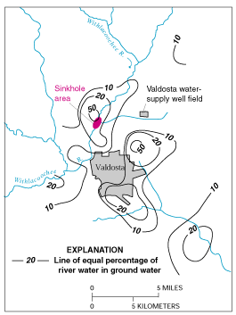
Figure E-1. Estimated percentage of Withlacoochee River water in ground water in the Upper Floridan aquifer, June 1991. (Modified from Plummer and others, 1998.)
The Upper Floridan aquifer, which is the sole source of water supply for Valdosta, Georgia, and much of the surrounding area, receives large volumes of direct discharge from the Withlacoochee River through sinkholes in the streambed or off-channel. A highly interconnected conduit system has developed in the Upper Floridan aquifer in this area, which extends at least 15 miles from the sinkhole area. Chloride and isotopic data were used by Plummer and others (1998) to map the percentage of Withlacoochee River water in ground water in the Upper Floridan aquifer (Figure E-1). These data indicate that ground water in parts of the Upper Floridan aquifer contains high percentages of recently recharged Withlacoochee River water. Plummer and others (1998) note that, although the patterns shown in Figure E-1 are generally true over the area, extreme variations can occur at a given location, as would be expected because of the large variations and discontinuities in hydraulic properties in the karst environment and time-varying inflows of river water into the aquifer.
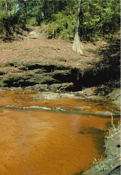
Sinkhole near the Withlacoochee River. (Photograph by Richard E. Krause, U.S. Geological Survey.)
The strong connection between the Withlacoochee River and ground water in the Valdosta area has created concerns about the potential for contamination of ground-water supplies by contaminants in the river. There also are concerns about the effects of natural organic matter in the river water. For example, in the early 1980’s, it was recognized that chlorination of aquifer water produced disinfection by-products in excess of drinking-water standards. This occurred as a result of reaction of chlorine with the high amounts of natural organic matter in the river water recharged to the aquifer.
Appendix B, Groundwater movement in the Floridan Aquifer.
In GROUND WATER ATLAS of the UNITED STATES: Alabama, Florida, Georgia, and South Carolina, HA 730-G, Floridan aquifer system, http://pubs.usgs.gov/ha/ha730/ch_g/G-Floridan6.html
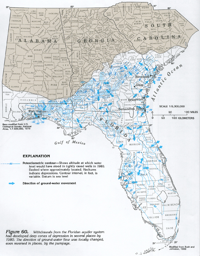
Figure 60 Map showing potentiometric contours and ground-water movement in the Floridan aquifer system in 1980 (608K),
Appendix C: Salt Water Intrusion
In Revised Hydrogeologic Framework of the Floridan Aquifer System in Florida and Parts of Georgia, Alabama, and South Carolina , By Lester J. Williams and Eve L. Kuniansky, Professional Paper 1807, First release: April 2015, Revised March 2016 (ver. 1.1), Groundwater Resources Program, U.S. Department of the Interior, U.S. Geological Survey, Reston, Virginia: 2015, https://pubs.usgs.gov/pp/1807/pdf/pp1807.pdf
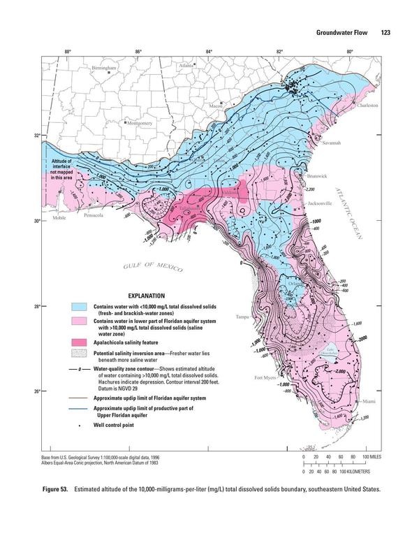
Figure 53. Estimated altitude of the 10,000-milligrams-per-liter (mg/L) total dissolved solids boundary, southeastern United States.
Appendix D: Withlacoochee Wastewater Treatment Plant overflows in 2009 and 2013
https://www.wctv.tv/home/headlines/Valdosta-Wastewater-Plant-Operational-Again-193059631.html
City of Valdosta Press Release,
March 3, 2013
Withlacoochee Wastewater Treatment Plant Fully Operational
At approximately 1:30 p.m. today, March 3, the Withlacoochee Wastewater Treatment Plant was brought online and returned to normal operation, after a loss of function for only three days compared to the nine days of complete loss of function experienced in the flood of 2009.
Today, the river receded to the point where the temporary by-pass pumps could be connected to the existing valves. The system was turned on, became fully operational and began full treatment capabilities.
Lessons learned from the 2009 flood resulted in proactive measures which include the following:
The installation of bypass pumps, pipes and valves to utilize in the event of an emergency or act of God.
In 2009, the berm only protected the pump station, which did not prevent flooding of the chemical building, the chlorine contact building, the filters and the belt presses. The plant’s electrical system was destroyed in the flooded area and the filters and belt presses were inoperable.
wwalswatershed@gmail.com PO Box 88, Hahira, GA 31632 Page of 850-290-2350 www.wwals.net
[1] 595 U. S. 143 (2021), MISSISSIPPI v. TENNESSEE ET AL., ON EXCEPTIONS TO REPORT OF SPECIAL MASTER, No. 143, Orig. Argued October 4, 2021—Decided November 22, 2021, https://www.supremecourt.gov/opinions/21pdf/143orig_1qm1.pdf
[2] Georgia Water Planning, accessed February 7, 2022, Suwannee-Satilla Regional Water Plan, https://waterplanning.georgia.gov/suwannee-satilla-regional-water-plan
[3] North Florida Regional Water Supply Plan, North Florida Regional Water Supply Partnership, accessed 5 September 2019, https://northfloridawater.com/watersupplyplan/index.html
[4] North Florida-Southeast Georgia (NFSEG) regional groundwater flow model, North Florida Regional Water Supply Partnership, accessed 5 September 2019, https://northfloridawater.com/groundwaterflowmodel.html
[5] Georgia Environmental Protection Division, Twin Pines Minerals, LLC, accessed February 7, 2022, https://epd.georgia.gov/twin-pines
[6] Kitchens, S and Rasmussen, TC. Hydraulic Evidence for Vertical Flow From Okefenokee Swamp To The Underlying Floridan Aquifer In Southeast Georgia. Proceedings of the 1995 Georgia Water Resources Conference, held April 11 and 12, 1995, at The University of Georgia, Kathryn J. Hatcher, Editor, Carl Vinson Institute of Government, The University of Georgia, Athens, Georgia. https://smartech.gatech.edu/handle/1853/44003 .
[7] Florida Department of Environmental Protection v. The Chemours Company FC, LLC, OGC FIle NO. 18-1240, in WWALS, Consent Order, FDEP v. Chemours involving Twin Pines Minerals 2019-02-07, https://wwals.net/?p=49898
[8] Russ Bynum, Associated Press, October 21, 2020, Trump environmental rollback spurs mining near Georgia's Okefenokee Swamp, https://wgxa.tv/news/state-news/trump-environmental-rollback-spurs-mining-near-georgias-okefenokee-swamp
[9] WWALS, February 7, 2022, Little Alapaha River, Swallet, Bridges, Source, Mouth 2022-02-07, https://wwals.net/?p=57695
[11] WWALS, January 21, 2022, Sullivan Slough and Blue Sink by Amanda Davis 2022-01-18, https://wwals.net/?p=57588
[12] “ More Floridan Aquifer Protection Called for by Sierra Club Petition to EPA,” Press Release, Sierra Club, 5 May 2015, http://www.sierraclubfloridanews.org/2015/05/more-floridan-aquifer-protection-called.html
-jsq, John S. Quarterman, Suwannee RIVERKEEPER®
You can join this fun and work by becoming a WWALS member today!
Short Link:
Pingback: Georgia Okefenokee protection bill filed on Okefenokee Swamp Day 2022-02-08 | WWALS Watershed Coalition (WWALS) is Suwannee RIVERKEEPER®