
Here’s yet another reason you can cite when you ask the Georgia Enviromental Protection Division (GA-EPD) to stop the mining proposal by Twin Pines Minerals (TPM) to strip mine near the Okefenokee Swamp, above the Floridan Aquifer.
David Pendered, Saporta Report, January 3, 2022 5:13 pm, Okefenokee Swamp mining proposal could be affected by Supreme Court ruling,
The proposal to mine sand near the Okefenokee Swamp could be affected by a groundbreaking ruling on water rights issued by the U.S. Supreme Court.
For the first time, justices have determined the same laws that apply to water flowing above ground apply to water in multi-state underground aquifers.
“This court has never before held that an interstate aquifer is subject to equitable apportionment,” Chief Justice John Roberts wrote in a unanimous opinion issued Nov. 22, 2021. This doctrine “aims to produce a fair allocation of a shared water resource between two or more States,” according to the ruling.
The ruling sets a legal foundation to manage future disputes over the usage of interstate groundwater. This issue is expected to arise more frequently as drought and climate change poise to alter the United States’ traditional water supplies and challenge agreements among governments to share water.
This ruling could be brought into play at the proposed mine near the Okefenokee, in part because of the amount of water to be extracted for mining operations from the four-state Floridan Aquifer. For that to happen, a party that has standing to file a lawsuit would have to do so on behalf of one or more of the four states that are above the Floridan Aquifer — Florida, Alabama, Georgia and South Carolina. Two of these states have previously litigated Georgia’s use of water from the Chattahoochee and Flint rivers. The Supreme Court ruled against Florida’s claim in April.
Twin Pines Minerals, LLC has filed an application for industrial groundwater withdrawal permit with Georgia environmental regulators. The company intends to mine sand from an area outside the southeastern border of the Okefenokee. Minerals in the sand are valued for their industrial uses.
The permit application seeks to extract 1.44 million gallons of water a day from the Floridan Aquifer. The application noted the U.S. Geological Survey had estimated extraction rate in 2010 of 11.1 million gallons a day by four counties that contain the swamp — Brantley, Charlton, Clinch and Ware counties.
A USGS report unrelated to the Twin Pines Minerals application states an estimated 3,271 million gallons a day were extracted from the Floridan Aquifer, in 2010, to meet the combined demands by agricultural and drinking water consumers.
To establish the precedent of equitable apportionment of an interstate aquifer, justices used a lawsuit filed by Mississippi against Tennessee. Mississippi contended that Tennessee was “siphoning” Mississippi’s water from the Middle Claiborne Aquifer through a network of wells in Tennessee. The aquifer stretches beneath eight states.
Roberts observed that justices disagree with Mississippi’s claim that it has sovereign ownership over all waters beneath its surface.
“Although our past cases have generally concerned streams and rivers, we see no basis for a different result in the context of the Middle Claiborne Aquifer,” Roberts wrote. “When a water resource is shared between several States, each one ‘has an interest which should be respected by the other. Mississippi’s ownership approach would allow an upstream State to completely cut off flow to a downstream one, a result contrary to our equitable apportionment jurisprudence.”
The Floridan Aquifer stretches about 100,000 square miles beneath the entire state of Florida, and parts of Alabama, Georgia, South Carolina, as well as portions of the Gulf of Mexico and the Atlantic Ocean. It is the water source for about 10 million people.
The aquifer provides water for agriculture, and for tourism and wildlife through its “crystal clear water that discharges to springs and streams providing recreational and tourist destinations and unique aquatic habitats,” according to USGS reports.
Twin Pines Minerals intends to conserve water by recycling and recirculating it during the production process, according to the application. Water that is not recycled will have been lost to evaporation or retained in the final product.
![[Figure 8. Drawdown 2930 days]](https://www.wwals.net/pictures/2019-07-24--tpm-ga-epd-water-withdrawal/424772086-7-24-19-Final-Application-for-Industrial-Groundwater-Withdrawal-Permit-0044.jpg)

This is the same Twin Pines Minerals that is still under a Florida Consent Order for not containing its wastewater at several titanium mine sites in north Florida. During Hurricane Irma, the only pollution spills in the Suwannee River Basin in Florida (other than from diesel trucks) were from those mine sites. Why should we trust TPM not to spill in Georgia, or not to let its containment ponds leak into the underlying groundwater?
As we pointed out back in 2019, It’s been known for at least a quarter century that the Floridan Aquifer probably interchanges water with the Okefenokee Swamp, which is the headwaters of the Suwannee and St. Marys Rivers, and thus the miners’ activities could affect the level or composition of both surface and groundwater, affecting both Georgia and Florida, as we cited in our September 2019 comments to the Army Corps. See Kitchens, S and Rasmussen, TC. Hydraulic Evidence for Vertical Flow From Okefenokee Swamp To The Underlying Floridan Aquifer In Southeast Georgia. Proceedings of the 1995 Georgia Water Resources Conference, held April 11 and 12, 1995, at The University of Georgia, Kathryn J. Hatcher, Editor, Carl Vinson Institute of Government, The University of Georgia, Athens, Georgia. https://smartech.gatech.edu/handle/1853/44003.
The miners’ own USACE permit application showed a cone of depression of Floridan Aquifer levels extending under the Swamp; see first image above. That figure curiously does not extend the cone to the south, where it must also go under Florida.
TPM has since reduced its water withdrawal request to GA-EPD, and submitted much more detailed groundwater modeling maps to GA-EPD. None of those new maps extend modeling into Florida, either.
Yet the problem of water withdrawals affecting aquifer levels over large distances is well known, for example as depicted in this map from the North Florida Regional Water Supply Plan (NFRWSP), prepared by Florida’s Suwannee River Water Management District (SRWMD) and St. John’s River Water Management District (SRWMD), using the North Florida-Southeast Georgia (NFSEG) regional groundwater flow model, examined effects of pumping by Savannah, Georgia, and Jacksonville, Florida, on south Georgia and north Florida. While flawed, the NFRWSP does indicate the widespread geographical implications of water withdrawals.
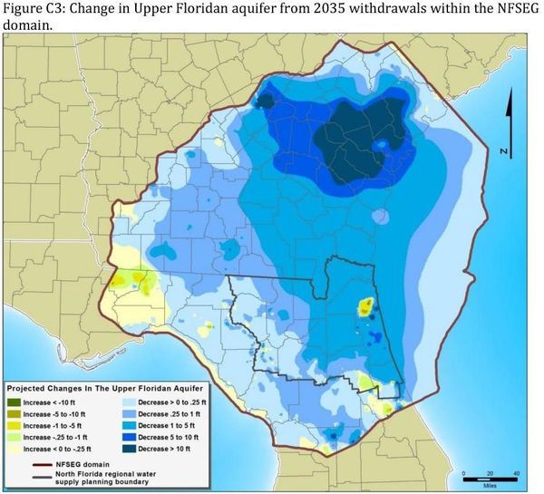
Figure 2. Widespread effects of water withdrawals on water levels in the Floridan Aquifer illustrated in NFRWSP.
The miners’ recent permit applications claim their activities will only affect surficial groundwater, but that is irrelvant to the Supreme Court decision, which appears to cover all groundwater. Plus much of the groundwater use on which all of south Georgia and north Florida depends comes from surficial aquifers. It’s no defense to say the mine site is across the St Marys River from Florida, because groundwater is well known to cross under rivers, as we pointed out to U.S. EPA back in April 2019, citing the case of Shadrick Sink west of the Withlacoochee River sending river water under the river miles east to the site of Valdosta, Georgia’s water wells, forcing that city to sink them deeper to get under the river water.
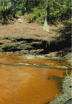
Sinkhole near the Withlacoochee River. (Photograph by Richard E. Krause, U.S. Geological Survey.)
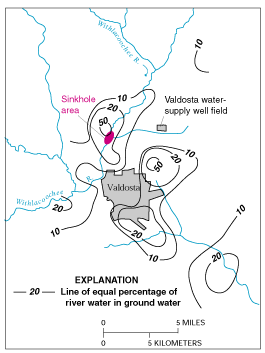 Figure E-1. Estimated percentage of Withlacoochee River water in ground water in the Upper Floridan aquifer, June 1991. (Modified from Plummer and others, 1998.)
See also for example the M2 Blue cave system, which crosses under the Withlacoochee River in Florida.
![[Gully / Swallet --KUR]](https://www.wwals.net/pictures/2021-01-01--withlacoochee-distributary/gully-swallet-m2-blue-kur.jpg)
Gully / Swallet –KUR
7/9/2016 – M2 Blue Exploration –Andrew Pitkin, KUR
See also the even larger Cathedral Cave System, which crosses under the Suwannee River and feeds Suwannachoochee Spring on the Withlacoochee River.

Falmouth dye trace shows connection to Ellaville and Suwannacooche Springs
And, due to cracks in the limestone containing all these levels of groundwater, the upper groundwater interchanges with the Floridan Aquifer.
What You Can Do
You can ask your local city or county government to pass a resolution suporting the Swamp and opposing the mine, as half a dozen cities and counties already have. The previous resolutions are on the WWALS website.
You can also
ask GA-EPD for a moratorium on mining permits,
or to deny the permits,
or at the very least to examine them very thoroughly and produce the equivalent of the Environmental Impact Statement that the Army Corps should have been working on.
https://wwals.net/?p=55092
You can also use Protect Georgia form to end a message to your Georgia statehouse delegation.
Floridians, this mine site is upstream from Florida, and groundwater down to the Floridan Aquifer crosses the GA-FL line, so you can also use these forms. Plus, it’s time to ask the Florida Department of Environmental Protection (FDEP) to intervene on behalf of the state of Florida.
-jsq, John S. Quarterman, Suwannee RIVERKEEPER®
You can join this fun and work by becoming a WWALS member today!
Short Link:
Pingback: More than 40 scientists oppose strip mine near Okefenokee Swamp 2021-11-30 | WWALS Watershed Coalition (WWALS) is Suwannee RIVERKEEPER®