
Water quality is worse upstream of Valdosta’s Withlacoochee WTP and far downstream of its Mud Creek WTP, according to Valdosta’s most recent data, received last week in response to a Georgia Open Records Act (GORA) request from WWALS. This is the recent data I mentioned in the tour of Valdosta WTPs.
Does this data mean Valdosta is perfect and will never spill again? Nope. But it does mean there’s more than one source of fecal coliform and E. coli. We need to find those other sources, which is one reason WWALS is starting a water quality testing program.
Mud Creek WTP
Valdosta’s smaller WTP is in the Alapaha River Basin.
Map, Mud Creek WTP
The WTP is the image left of top center, St. Augustine Road is the green diamond top left, Johnson Road is the grey diamond below and left of top center, and GA 135 Alapahoochee is the grey diamond bottom right.

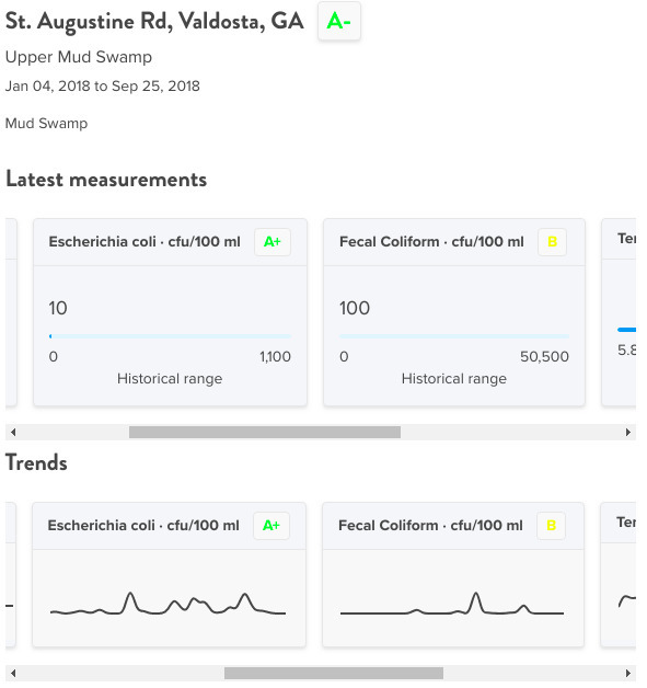
St. Augustine Rd., Mud Creek, Mud Creek WTP
100 and 10 are good readings for Fecal Coliform and E. coli, upstream of the Mud Creek WTP.
Johnson Road, Mud Creek, Mud Creek WTP
150 and 85 are within the state limits for Fecal Coliform and E. coli, and this is downstream of the Mud Creek WTP.

GA 135, Alapahoochee River, Mud Creek WTP
210 is above the state limit of 200 for Fecal Coliform. 165 is below the state limit for E. coli, but still not good. This is far downstream of the Mud Creek WTP, just above the GA-FL line.

Withlacoochee WTP
Valdosta’s larger and more notorious WTP is in the Withlacoochee River Basin.
Map, Withlacoochee WTP
Click on the image icon on the right (the thing that looks like mountains) to see the WWTP is marked by the small image near US 84 and the label Kinderlou. US 41 is at the gray diamond top right, GA 133 the orange diamond just west of I-75, US 84 the grey diamond on the left, and GA 31 or Madison Highway at Horn Ferry Bridge is the green diamond lower right.

US 41, Withlacoochee River, Withlacoochee WTP
225 is above the state limit of 200 for Fecal Coliform, and this is miles above the Withlacoochee WTP.

GA 133, Withlacoochee River, Withlacoochee WTP
415 cfu/100 ml Fecal Coliform is well above the 200 state limit. It’s curious that E. Coli only shows 110. GA 133 is still miles above the Withlacoochee WTP, although downstream from Sugar Creek.

US 84, Withlacoochee River, Withlacoochee WTP
60 and 10 are quite good readings for Fecal Coliform and E. coli, downstream of the Withlacoochee WTP.

GA 31, Withlacoochee River, Withlacoochee WTP
20 and 10 are very good readings for Fecal Coliform and E. coli, and this far downstream of the Withlacoochee River WTP, just upstream of the GA-FL line.

Water Reporter Map
Data from Valdosta weekly since January 2017 is in this Water Reporter Map. For some points, such as US 41, you’ll need to zoom in close to distinguish multiple data collections, because we also have data from Lowndes County for some dates. Lowndes County runs its own sewer system, with a Land Application Site (LAS), not a WTP.
Thanks to Scott Fowler, Environmental Manager, Valdosta Utilities, and Teresa Bolden, Valdosta City Clerk, for this Valdosta data.
For more water quality results and spills, see Valdosta (and other) Wastewater.
-jsq, John S. Quarterman, Suwannee RIVERKEEPER®
You can join this fun and work by becoming a WWALS member today!
Short Link: