
Here is (at least some of) the water quality testing data Valdosta was required to collect after its major spills of June in the Withlacoochee River basin and August in the Alapaha River basin. Maybe Valdosta is right that neither of these spills got into waterways, but something sure did, according to this data. Curiously, in both cases the worst fecal coliform readings were upstream from the spill location.
Mud Creek WTP after the 13 August 2018 spill
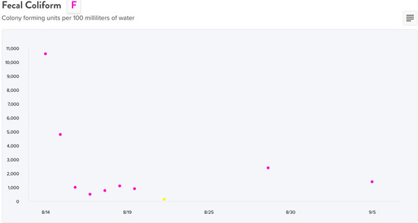
Downstream at Johnson Road on Mud Creek from
the Mud Creek WTP after the August spill

Upstream at Inner Perimeter Road on Mud Creek from the Mud Creek WTP after the August spill
Upstream also only one datapoint below 200 cfu/100 ml, and not in the same week as downstream.

The Mud Creek WTP is indicated by the image between the two F-grade water quality data blobs on the
Water Reporter map.
I’m guessing I correctly positioned the data collection stations on that map, from the allusion in the data; see below.
The data
Thanks to Valdosta City Clerk Teresa Bolden for scanning and emailing this data, free of charge.

Image of the
PDF file the City Clerk emailed.
What’s your opinion? Does it look to you like this data was prepared on a typewriter, or handwritten? It looks to me like it was prepared in electronic format on a computer. Yet despite my request (see below) for electronic format, what I got was scanned paper. Which is better than paper not scanned, I suppose.
I’m interpreting “Fecal Results” to mean fecal coliform.
I don’t know why Valdosta only returned that one parameter, when other permitted organizations, such as Lowndes County, also sent readings for dissolved oxygen, temperature, and pH to GA-EPD. Maybe it’s something special in Valdosta’s NPDES permits. Maybe I’ll ask GA-EPD what Valdosta sent to the state of Georgia.
Onwards to the other Wastewater Treatment Plant (WTP) and the other followup data.

Withlacoochee WTP to the west and Mud Creek WTP to the east of Valdosta.
Withlacoochee WTP after the 26 June 2018 spill

Below at US 84, after the
26 June 2018 WWTP spill.

Above at GA 133, after the
26 June 2018 WWTP spill.
Below the WTP there’s one datapoint below the state limit, in the same week as the lowest datapoint below.

The WWTP is indicated by the image in the middle,
with US 84 to the left and GA 133 above right on the
Water Reporter map.
We also got another GORA response from Valdosta today. More on that later.
-jsq, John S. Quarterman, Suwannee RIVERKEEPER®
You can join this fun and work by becoming a WWALS member today!
The GORA request
Here’s what I sent to Valdosta Utilities and the Valdosta City Clerk, Friday, 14 September 2018, at 1:57PM EDT:
Dear Valdosta Utilities and Valdosta City Clerk,
Pursuant to the Georgia Open Records Act
(O.C.G.A. § 50-18-70 et seq., also known as GORA),
I am requesting data from all followup water quality testing
required by the NPDES permits
for the Withlacoochee WTP and the Mud Creek WTP,
after the recent spills there, which were on
June 26, 2018 and August 13, 2018, respectively.If I am not mistaken, the applicable permits are:
Withlacoochee WPCP NPDES Permit No. GA0033235
located at 3352 Wetherington Lane, Valdosta, Georgia 31603 https://www.wwals.net/pictures/2018-08-30–permits/valdosta/NPDES-Permit-No-GA0020222-Final-Permit-Mod-2016-1.pdfMud Creek WPCP NPDES Permit No. GA0020222,
located at 1638 New Statenville, Valdosta, Georgia 31603 https://www.wwals.net/pictures/2018-08-30–permits/valdosta/NPDES-Permit-No-GA0033235-Final-Permit-Mod-2016.pdfI agree to pay any copying and/or administrative costs incurred in fulfilling my requests to the extent permitted by Georgia law. Such costs may include copying charge of $.10 per page and administrative charges for search, retrieval, and other direct administrative costs, such administrative charges not to exceed the salary of the lowest paid full-time employee who, in the discretion of the custodian of the records, has the necessary skill and training to perform the request. (The requester is not charged for the first fifteen minutes of time).
However, the relevant data is very likely in electronic format
and I request to receive it in electronic format via email.
If at all possible, in a spreadsheet would be best.
If the data exists only on paper, scans would work.My contact information is as below.
In a separate email message, I am filing another GORA request. Please do not delay one waiting for data for the other. Whichever you have first, please go ahead and send it.
For the rivers and the aquifer,
John S. Quarterman,
Suwannee RIVERKEEPER®
229-242-0102
contact@suwanneeriverkeeper.org
www.suwanneeriverkeeper.org,WWALS Watershed Coalition, Inc.
850-290-2350
wwalswatershed@gmail.com
www.wwals.net
PO Box 88, Hahira, GA 31632WWALS is the WATERKEEPER® Alliance
Member for the Suwannee River
and its tributaries the Withlacoochee,
Little, Willacoochee, and Alapaha Rivers.WWALS is a member of
Georgia River Network, Georgia Water Coalition,
Floridians Against Fracking, and national River Network.
-jsq, John S. Quarterman, Suwannee RIVERKEEPER®
You can join this fun and work by becoming a WWALS member today!
Short Link: