
While Alabama is thinking about it (actually, Alabama already does it) and Georgia requires an open records request with slow response (since 2018-12-21 Georgia now posts spills),
Florida has already required and is publishing timely notices of spills, and more recentlyh a map of the most recent 30 days of spills!
Among them, surprisingly few in the Suwannee River Basin from Hurricane Irma: three in Baker and Bradford Counties from The Chemours Company, and two from Camp Blanding.
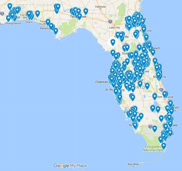
Follow this link for the interactive google map.
Daniel H. Thompson, Lexology, 4 May 2017, Florida Legislature Passes “Public Notice of Pollution Act”
On May 3, 2017, the Florida House of Representatives unanimously voted in favor of the “Public Notice of Pollution Act,” which had already unanimously passed in the Florida Senate as Senate Bill 532. Before final passage SB 532 became part of SB 1018. Governor Scott had previously asked the Florida Legislature to approve and send him a pollution notification bill. He now has announced his intention to sign the bill, which upon enactment will be codified at Sections 403.076-403.078, Florida Statutes, with an effective date of July 1, 2017.
The Act does not expand the types of pollution events that must be disclosed to the Florida Department of Environmental Protection (“FDEP”), but rather provides a significant expansion in how those events must be reported. The Act requires an owner or operator of a facility that has a “reportable pollution release” to provide notice of such a release to the FDEP within 24 hours of discovery, and to report again within 24 hours if such owner or operator subsequently discovers that the release has migrated beyond the facility’s property boundaries. Within 24 hours of such notice, the FDEP must provide a notice of the release by posting it on a designated public website and emailing it to a list of local government agencies, news media, and similar entities as established in the Act, as well as to anyone else who asks to be on an email list for such notices. The FDEP has authority to adopt rules to implement the Act.
This reporting requirement is a significant expansion on current law to the extent that it expands the procedure for how pollution events are reported to the public. Under current law, reports of pollution events to the FDEP are public records, but they usually are only filed with the FDEP, and only become really “public” if someone makes a public records request for them, assuming that person knows what to ask for. In the Mosaic case discussed below, the company reported a groundwater discharge to the FDEP, but local residents were unaware of the event for many weeks simply because no one knew to ask for the reports. As the result of passage of the Act, it is very likely that the locals would know about it much more quickly, because of both the much wider distribution of notice and the two 24-hour reporting requirements.
And FDEP now has a Pollution Notice web page:
In compliance with Section 403.077, F.S. and the public interest, the Department of Environmental Protection is making available any Notices of Pollution that it has received. This information is available below.
This information is presented as provided by the reporting entity. The Department of Environmental Protection is not responsible for the accuracy of any information submitted.
Google Map by WWALS
That website’s data is downloadable in Excel, which has latlongs in it. Here’s a google map:
I hope somebody will tell me there’s a way to get FDEP’s Map Direct to show this stuff as a layer. As it is, each point on the google map above has a link into Map Direct for that one point.
Spills in the Suwannee River Basin
Meanwhile, there were surprisingly few pollution reports from the Suwannee River Basin in Florida: none actually during Hurricane Irma.
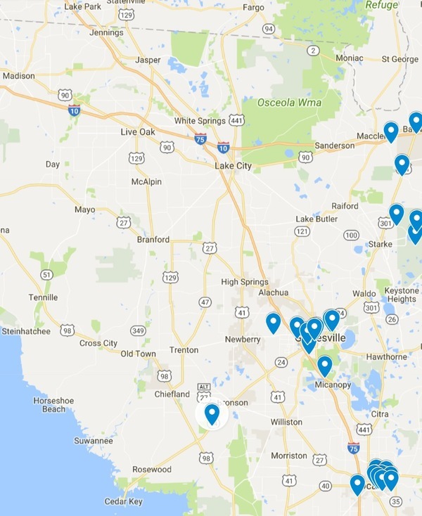
Follow this link for the interactive google map.
On 18 September 2017, there were three reports from Baker and Bradford County by The Chemours Company:
-
Chemours North Maxville Mine
09/18/2017 03:46:42 EDT
The Chemours Company – North Maxville Mine PO Box 753; 7775 S CR 228; Starke, FL; 32091
State Watch office has not yet assigned incident Number. Due to the significant rain event associated with Hurricane Irma, Stormwater and process water was released from the emergency spillways at at one mining cell (turbid water – no hazardous materials or chemicals). Discharge from the emergency spillways ceased over the course 2 dyas days. , , -
Chemours Maxville Mine
09/18/2017 03:25:31 EDT
The Chemours Company – Maxville Mine PO Box 753; 780 Hwy 301, Maxville; Starke, FL; 32091
State Watch office has not yet assigned incident Number. Due to the significant rain event associated with Hurricane Irma, Stormwater and process water was released from the emergency spillways at 4 of the ponds on the site (turbid water – no hazardous materials or chemicals). Discharges from the emergency spillways ceased over the course of a few days. , , Additionally, turbid water was released from NPDES point (D001). Due to high winds, sediment was not able to be settled from the water column., , , , -
Chemours – Trail Ridge
09/18/2017 04:04:05 EDT
The Chemours Company – Trail Ridge PO Box 753; 5222 Treat Road; STARKE, FL; 32091
State Watch office has not yet assigned incident Number. Due to the significant rain event associated with Hurricane Irma, Stormwaterwas released from the emergency spillway at the West Levee.
And Camp Blanding had two vehicular accidents involving spills:
-
20175656: Diesel release from vehicle collision
08/08/2017 10:31:03 EDT
Camp Blanding Joint Training Center 5629 State Road 16 West; Starke, FL; 32091
Collision of military vehicle (large transporter) with F150 pickup truck attached to trailer with boat occurred on 26 July 2017. On 27 July 2017, at time of discovery of fuel loss, original estimate was determined at potentially 120-130 gallons based off typical schedule for filling the tanks of the military vehicle and this was reported initially to the State Watch Office. However, after moving the boat (where initially thought the diesel had ended up) visual inspection determined that much less (potentially 25 gallons) had actually leaked out than originally estimated and reported. Tanks on boat still intact with no loss of fuel. Trenches dug and lined with oil-absorbing socks/booms, and bermed to capture any runoff. Contaminated soil covered and contained for removal. Final estimation for amount of diesel loss will be determined per the remediation report.
-
201716687: Tank Truck Accident
09/14/2017 02:29:38 EDT
Camp Blanding Joint Training Center 5629 State Road 16 West; Starke, FL; 32091
Back-end of trailer transporting diesel tank trucks for emergency fuel sites on post slipped off corner of road. Diesel released from top of one of the tank trucks. Original maximum estimation of diesel release: 100 gal, as reported to State Watch Office last night. Actual release: 53 gallons, after measuring/comparing initial and remaining tank volume.
There’s is a logging truck incident shown between Bronson and Otter Creek, but that was back in August:
-
20176020: Weems and Sons Logging
08/09/2017 09:48:50 EDT
Shoulder of SR 24 between Bronson and Otter Creek; Bronson, FL; 32621
Severity: Local Incident ,
Description: Diesel Fuel Release ,
This situation involves: Petroleum Spill ,
Affected Sectors: DEP District – Northeast, DEP OER Jacksonville – Day ,
Initial Report: AAG Environmental reported a diesel fuel release of 80 gallons due to a vehicle accident on SR 24. The release was contained and cleanup actions have been taken. The reporting party is plans to remove the impacted soil. ,
Injuries: Unknown ,
Fatalities (Unconfirmed by State Medical Examiner): Unknown ,
Environmental impact: Unknown ,
Incident Occurred: 7/25/2017 14:41 ET ,
Most Recent Update Date/Time: 08/08/2017-16:40 ET ,
Most Recent Update: N/A ,
Affected Counties: Levy ,
Facility Name or Description: SR 24 ,
Incident Location: Lat: 29.3663, Long: -82.7242 ,
Coordinates: Lat: 29.3663, Long: -82.7242 ,
There’s also FlaWARN, of which Suwannee Riverkeeper is an Associate Member.
Georgia could try to catch up with Florida and Alabama.
-jsq, John S. Quarterman, Suwannee RIVERKEEPER®
You can join this fun and work by becoming a WWALS member today!
Short Link:
Pingback: Alabama stricter sewage spill regulations and notification | WWALS Watershed Coalition (Suwannee RIVERKEEPER®)
Pingback: SWIM Plan Meeting, Live Oak 2017-10-03 | WWALS Watershed Coalition (Suwannee RIVERKEEPER®)
Pingback: Alabama sends email for sewage spills 2017-09-01 | WWALS Watershed Coalition (Suwannee RIVERKEEPER®)