
Update 2016-11-14: GWC Dirty Dozen Press Conference at US 84 Bridge with tour of Sabal Trail HDD 2016-11-16
Update 2016-11-13:Sabal Trail still leaking drilling mud into the Withlacoochee River at US 84 in GA 2016-11-12
FOR IMMEDIATE RELEASE
Hahira, GA, November 11th 2016 —
Sabal Trail leaked drilling mud up from their HDD pilot hole into the Withlacoochee River.
 They knew this before WWALS asked two weeks ago
what is that yellow thing in the river?
They did not tell WWALS or the public that this thing
they testified could not happen did happen.
The
evidence is in writing from Sabal Trail’s contractor
to the Georgia Environmental Protection Division.
They knew this before WWALS asked two weeks ago
what is that yellow thing in the river?
They did not tell WWALS or the public that this thing
they testified could not happen did happen.
The
evidence is in writing from Sabal Trail’s contractor
to the Georgia Environmental Protection Division.
This wasn’t even the actual horizontal directional drilling (HDD) borehole: it was just the smaller pilot hole. What will happen to the Withlacoochee River (or nearby water wells) with the main borehole? What will happen to the Ochlockonee River west of Moultrie, GA? What will happen to the Santa Fe River, where Sabal Trail is drilling now, or the Suwannee River, where it will drill soon, both Outstanding Waters of Florida, supposed to have extra measures of environmental protection? What about the Tallapoosa, Chattahoochee, or the other Withlacoochee (south) River?
“Why should we accept any risk to our waters, or eminent domain to take our lands, for an unnecessary pipeline, now that even FPL admits Florida needs no new electricity until 2024 at the earliest?” asked John S. Quarterman, president of WWALS Watershed Coalition, the Waterkeeper® Alliance Affiliate for the upper Suwannee River Basin.
Sabal Trail told a judge in WWALS v Sabal Trail & FDEP that drilling mud could not leak up into the Suwannee River because the HDD was too deep under the riverbed. Well, it already happened to the Withlacoochee River between Quitman and Valdosta, Georgia.
Sabal Trail also told FERC and U.S. Congressman Sanford Bishop (GA-02) that it was “impossible” for HDD under the Withlacoochee River to affect Valdosta’s water wells. Well, if one impossible thing has happened, what else can happen? If one conduit was opened by a mere HDD pilot hole, what other conduits were opened, or are being opened by the main HDD borehole?
The Madison County, FL Board of County Commissioners asked the Army Corps to investigate that “impossible” claim. The Corps refused and issued a permit for Sabal Trail.
After WWALS sent a second email request Wednesday to FERC, USACE, and GA-DNR, yesterday I called all three.
FERC’s John Peconom has not answered any inquiries from WWALS for months and still did not. His main office didn’t know his name, and his boss didn’t answer; I left a message.
The Albany, Georgia contact telephone for the Army Corps got a robot that didn’t know Terry Kobs existed, so I called the Corps Savannah office and left a message; no response.
Georgia Department of Natural Resources in Atlanta did call back late yesterday from Atlanta, and again today from Albany. Thanks to Georgia Environmental Protection Division (EPD) for working on a holiday and delivering this information in response to a Georgia Open Records Act (GORA) request.
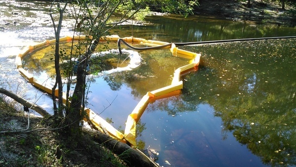
View from the south bank of Sabal Trail turbidity curtains and pipe from the north bank of the Withlacoochee River, about 2000 feet upstream from the US 84 bridge.
Photo: John S. Quarterman, October 22nd 2016.
These emails still don’t explain what that black pipe is coming from the Brooks County (north) side of the river. The Sabal Trail contractor emails say
“A vac truck is positioned on the south bank and the mud is being recovered as it is released.”
Unless Sabal Trail doesn’t know south from north, that doesn’t explain the black pipe coming from the north bank, which also doesn’t touch the water, and thus is not removing anything from the river.
The contractor also wrote:
“No plume extends beyond the site of the release. Crews will continue to monitor and recover the release for as long as it occurs.”
What’s this thing downstream from the turbidity curtains?

Loose item downstream from Sabal Trail turbidity curtains in the Withlacoochee ver.
Photo: John S. Quarterman, October 22nd 2016.
Quarterman added, “It looks like some of their stuff broke loose and drifted downstream. And how do they know there is no plume underground in the groundwater or deeper in the aquifer?”
About WWALS Watershed Coalition:
WWALS Watershed Coalition, Inc., (WWALS) is the WATERKEEPER® Alliance Affiliate for the upper Suwannee River.
WWALS advocates for conservation and stewardship of the Withlacoochee, Willacoochee, Alapaha, Little, and Upper Suwannee River watersheds in south Georgia and north Florida through education, awareness, environmental monitoring, and citizen activities.
Contact:
John S. Quarterman, President
WWALS Watershed Coalition, Inc.,
229-242-0102
wwalswatershed@gmail.com
www.wwals.net
PO Box 88, Hahira, GA 31632
Evidence:
Below are the emails from Sabal Trail’s contractor forwarded today by GA-EPD to WWALS in response to a WWALS open records request:
From: RYAN CHILDS [mailto:cimarronenvironmental@msn.com]
Sent: Friday, October 21, 2016 6:39 PM
To: Freeman, Joe
Subject: Sabal Trail Transmission, LLC – Withlacoochee River CrossingJoe,
Thanks for coming out to the Withlacoochee River crossing and meeting with Chad Baker and others. Unfortunately, later this afternoon actual drilling mud did start appearing in the river, approximately 8-ft from the south bank in approximately 2-ft of water depth. The release is very slow and is contained by a combination of BMPs, including sandbags and turbidity curtains. A vac truck is positioned on the south bank and the mud is being recovered as it is released. No plume extends beyond the site of the release. Crews will continue to monitor and recover the release for as long as it occurs.
Wanted you to be aware and I called it in to your office at the time I was informed. Please don’t hesitate to call myself or Chad at any point for an update.
Thanks,
Ryan H. Childs
Environmental Permit Coordinator
321-249-8641 (office)
307-760-5635 (cell)
cimarronenvironmental@msn.comAssigned to: Sabal Trail Transmission, LLC
400 Colonial Center Pkwy., Suite 300
Lake Mary, FL 32746Employee of: Cimarron Env. Consulting, Inc.
PO 1109
Laramie, WY 82073
From: RYAN CHILDS [mailto:cimarronenvironmental@msn.com]
Sent: Thursday, October 20, 2016 6:52 PM
To: Freeman, Joe
Subject: Sabal Trail Transmission, LLC – Withlacoochee River CrossingJoe,
Left a message on your office voicemail suggesting you call me tomorrow. We’re currently drilling our HDD pilot hole at the Withlacoochee River crossing. This afternoon some kind of substance started appearing on the surface of the water, looking like a broken up algae pattern, whitish/greyish brown in color, much like a thick algae in feel. Doesn’t appear to be any drilling mud on the riverbed surface as one would expect in an inadvertent return situation. Not completely sure it’s associated with our activities, but out of abundance of caution we deployed a turbidity curtain downstream of where the substance is appearing and skimmed it off the surface using buckets. The substance appeared for about an hour, stopped at some point while we paused drilling, and resumed again sometime well after we resumed drilling. Crews are continuing to monitor the situation, maintain the turbidity curtain, and collect any material that appears. The pilot hole is estimated at about 400-ft short of exit at this time.
I’d appreciate a call sometime tomorrow if you have a chance; wanted to make you aware of the situation.
Thanks,
Ryan H. Childs
Environmental Permit Coordinator
321-249-8641 (office)
307-760-5635 (cell)
cimarronenvironmental@msn.comAssigned to: Sabal Trail Transmission, LLC
400 Colonial Center Pkwy., Suite 300
Lake Mary, FL 32746Employee of: Cimarron Env. Consulting, Inc.
PO 1109
Laramie, WY 82073
===
You can join this fun and work by becoming a WWALS member today!
Short Link:
Pingback: What is Sabal Trail sending into the WIthlacoochee River between Quitman and Valdosta, GA? WWALS PR 2016-11-09 | WWALS Watershed Coalition
Pingback: Sabal Trail still leaking drilling mud into the Withlacoochee River at US 84 in GA 2016-11-12 | WWALS Watershed Coalition